
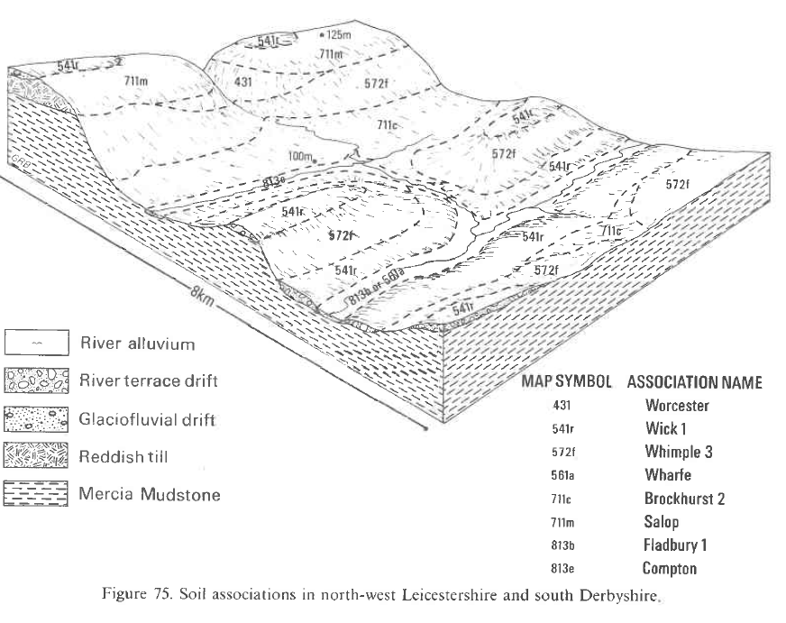
Soil Associations
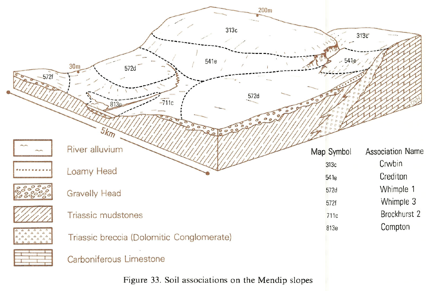
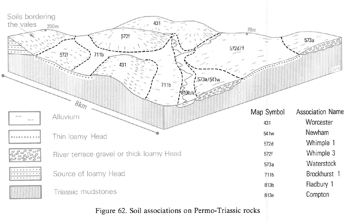
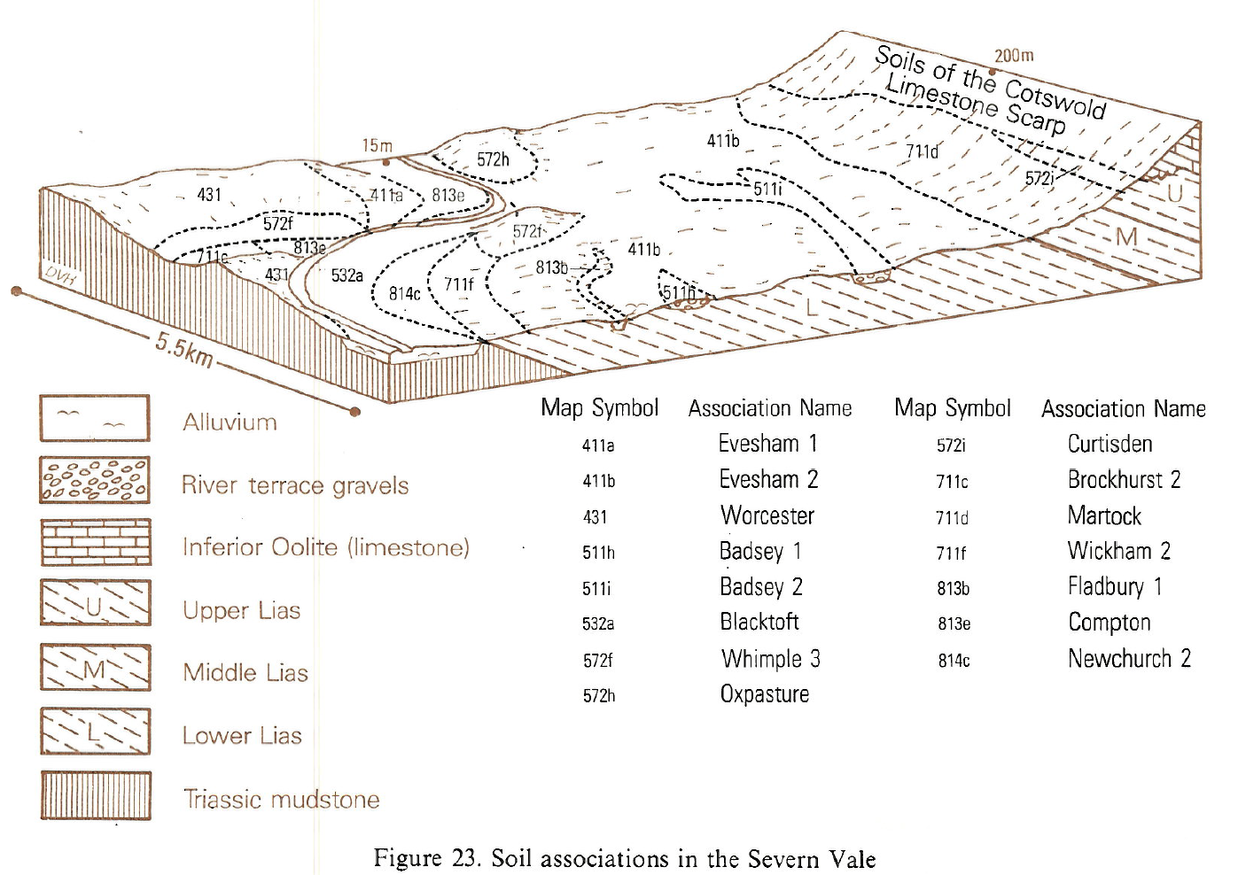
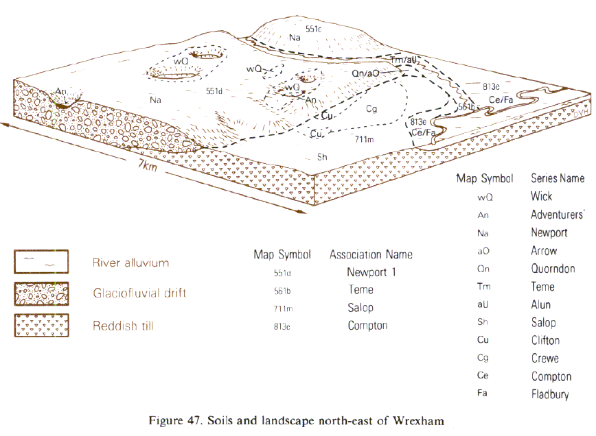
0813e COMPTON
Soil and site characteristics
Stoneless mostly reddish clayey soils affected by groundwater. Flat land. Risk of flooding.
Geology
Reddish river alluvium
Cropping and Land Use
Permanent grassland with dairying and stock rearing.
Component soil series
| Subgroup | Series name | Percentage | WRB 2006 link |
|---|---|---|---|
| 8.13 | COMPTON | 70% | Clayic Fluvic Eutric Gleysols |
| 8.13 | FLADBURY | 10% | Clayic Fluvic Eutric Gleysols |
Covers 251 km2 in England and Wales
Soilscapes Classification
| 20 |
Loamy and clayey floodplain soils with naturally high groundwater |
0813e COMPTON
Detailed Description
The Compton association contains clayey, severely waterlogged soils developed in reddish and greyish river alluvium subject to seasonal flooding. It occupies low-lying flat ground along the floodplains of rivers and streams draining Triassic mudstone outcrops and is most common in the Midlands and South West England. Small areas are also mapped in south Wales and east of Wrexham. The association is dominated by reddish clayey alluvial gley soils of the Compton series, which have prominently mottled reddish and greyish subsoils which usually pass downwards into permanently waterlogged, greyish clay within 1 m depth. The reddish colours come from nearby reddish rocks, primarily of Triassic age. Along narrow valleys cut in Triassic mudstone, the association consists almost entirely of Compton soils. On broader river floodplains however, greyish clayey alluvial gley soils of the Fladbury series are found in backland areas and hollows. Here, prolonged waterlogging at shallow depth has produced a predominantly grey subsoil. Fladbury soils also occur where local streams drain outcrops of non-reddish rocks such as Lias clay or Carboniferous shale. Both Compton and Fladbury soils often become coarser at depth, with fine loamy or fine silty horizons below 50 cm depth. The reddish, clayey Dosthill series (Whitfield and Beard 1980), typical humic alluvial gley soils, forms a minor but consistent component of the association. It is distinguished from the Compton series by its dark coloured, organic-rich humose topsoil and usually occupies wet hollows in narrow valleys, or fringes Fladbury soils on the broader river floodplains.
The association is widespread and covers about 157 km², mainly in narrow strips scattered throughout the region. It occurs along the lower reaches of the Dee and Gowy in north-west Cheshire; in the Roden and Duckow valleys in north Shropshire and in the Tame and Anker valleys in Warwickshire. It is also found throughout the Salwarpe and Arrow valleys and along minor streams west of Worcester. Other occurrences are along the river Mease on the south Derbyshire-Leicestershire border, in the valleys of many streams draining Triassic mudstone on both sides of the Trent and in broad low-lying alluvial basins at Austrey Meadows in north Warwickshire and Longdon and Eldersfield Marshes in south Worcestershire. Reddish fine loamy gleyic brown alluvial soils of the Tewkesbury series form random inclusions in north-west Leicestershire most commonly along the upper reaches of the valleys. In north Warwickshire, along the Anker and Tame and around Austrey Meadows, Stixwould series is common. Soils of the Midelney series, with peat in the lower part of their profile, are included along the rivers Dee and Gowy.
The association covers some 23 km² in Clwyd, Gwent and South Glamorgan. It is found along the River Dee east of Wrexham, near Penarth, around the mouth of the River Rhymney and north-east of Usk. Occasional profiles of the Midelney series with clayey alluvium overlying peat within 80 cm depth are included along the Dee. Clyst, Tewkesbury and Stixwould series are rare.
The association covers some 80 km² mainly along the lower Severn valley in Gloucestershire and Avon, around the fringes of the Somerset Levels and Moors and on the floodplains of several rivers in Somerset and Devon, for example, the Tone near Taunton and the rivers Culm and Clyst near Exeter. Along the lower Severn valley, weakly mottled reddish clayey, fine silty and fine loamy soils of the Clyst, Hollington and Tewkesbury series occur on levees and humose Dosthill soils are often found in backland positions. Rare profiles of the Stixwould series occupy some slightly higher sites over terrace deposits. Tewkesbury soils occur on levees. Reddish weakly mottled clayey soils of the Clyst series predominate in the Tone and Clyst valleys, where Compton soils are confined to backlands with small patches of reddish fine loamy typical alluvial gley soils of the Dolphenby series. A similar pattern is found in the Culm valley, but here fine loamy soils are more common and Tewkesbury soils occupy much of the floodplain.
Soil Water Regime
The association occupies flat low-lying floodplains and the soils are subject to prolonged waterlogging by groundwater at shallow depths. They also suffer occasional damaging floods which can be extensive and protracted during the winter. When drained, both Compton and Fladbury soils can be improved to Wetness Class III or Wetness Class IV depending on their height above the river level. Underdrainage treatment is often impractical, however, because of the lack of adequate fall and in such cases the soils are severely waterlogged (Wetness Class V). Subsoil waterlogging caused by rising groundwater is accentuated by seasonal surface wetness. Although the soils have moderate or strong structure under old pasture, there are few pores within peds and excess water percolates through profiles mainly along fissures and earthworm channels. For most of the summer, when they are slightly moist or dry, soils are well fissured and relatively permeable, but because of their clayey nature, peds swell quickly as they become wetter during the autumn. As a result fissures and cracks quickly close, making the soils slowly permeable and subject to severe waterlogging in the autumn, winter and spring.
Cropping and Land Use
The soils are mostly under permanent grass or rough grazing. Prolonged waterlogging at shallow depths and the risk of damaging seasonal floods preclude arable crops in all but the highest parts of the floodplain. Grassland is used mainly for stock rearing because waterlogging, winter floods and the large amounts of moisture retained by topsoils, make cattle grazing safe only in summer. In most places the soils have an appreciable risk of poaching, but in the driest areas of eastern Nottinghamshire the risk is only slight. In Wales all the soils have a serious poaching risk and grassland needs to be very carefully managed to achieve consistent growth.
0813e COMPTON
Distribution Map
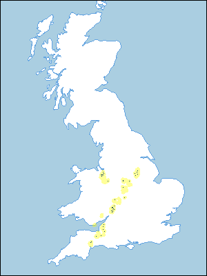 |
Note that the yellow shading represents a buffer to highlight the location of very small areas of the association.
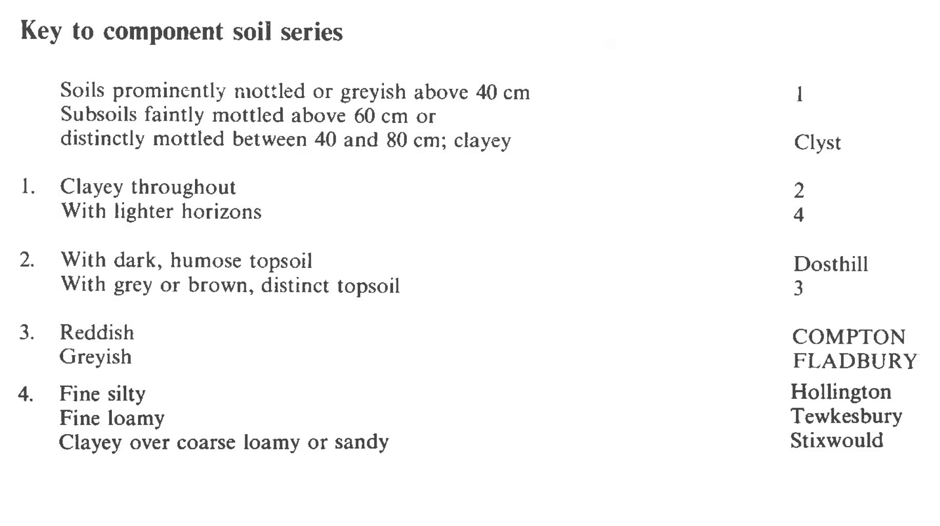
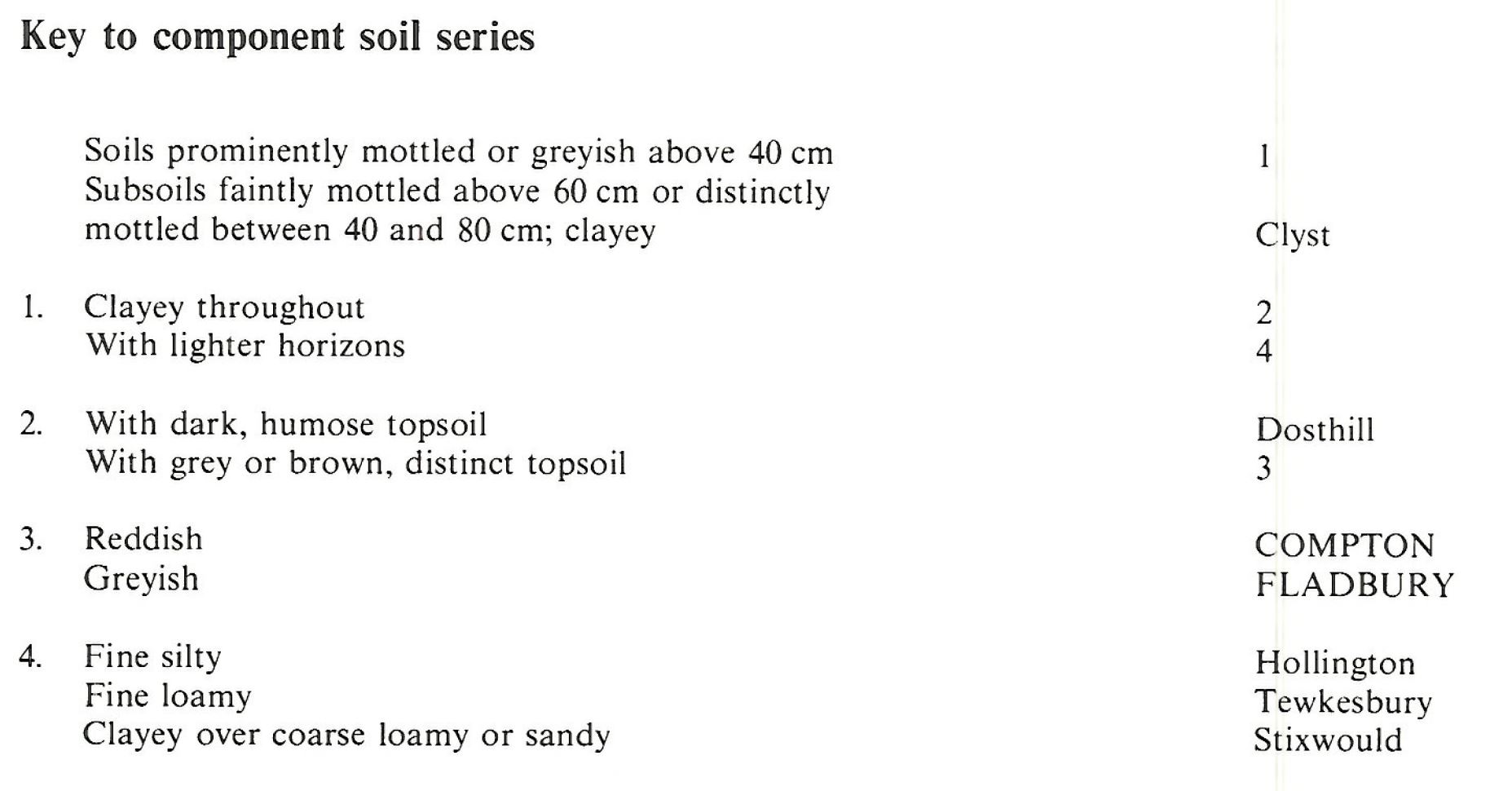
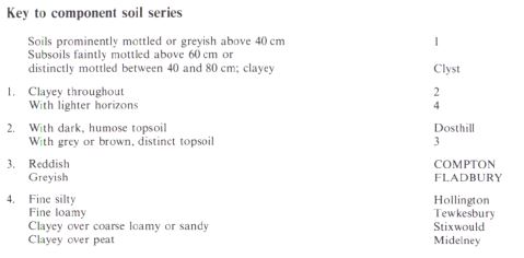
Keys to component soil series
Midlands
 |
South Western Region
 |
Wales
 |
Typical Landscapes
South Western Region
 |
South Western Region
 |
South Western Region
 |
Wales
 |
Midlands
 |
All information Copyright, Cranfield University © 2025
Citation: To use information from this web resource in your work, please cite this as follows:
Cranfield University 2025. The Soils Guide. Available: www.landis.org.uk. Cranfield University, UK. Last accessed 25/04/2025
