Soil Associations
0813h Dowels
Soil and site characteristics
Stoneless clayey soils, in places calcareous, often over peat. Some calcareous coarse and fine silty soils locally. Complex soil pattern with the coarser soils often on low ridges. Groundwater controlled by ditches and pumps.
Geology
Marine alluvium over peat
Cropping and Land Use
Sugar beet, other arable crops and some field vegetables.
Component soil series
| Subgroup | Series name | Percentage | WRB 2006 link |
|---|---|---|---|
| 8.13 | DOWELS | 35% | Clayic Fluvic Eutric Thaptohistic Gleysols |
| 8.14 | FAIRFIELD | 15% | Thaptohistic Fluvic Calcaric Gleysols |
| 8.14 | NEWCHURCH | 15% | Clayic Fluvic Calcaric Gleysols |
| 8.12 | WISBECH | 10% | Fluvic Calcaric Gleysols |
| 8.12 | AGNEY | 10% | Fluvic Calcaric Gleysols |
| 8.12 | STOCKWITH | 10% | Fluvic Calcaric Gleysols |
Covers 95 km2 in England and Wales
Soilscapes Classification
| 21 |
Loamy and clayey soils of coastal flats with naturally high groundwater |
0813h Dowels
Detailed Description
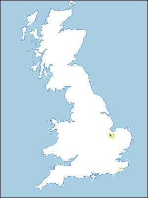
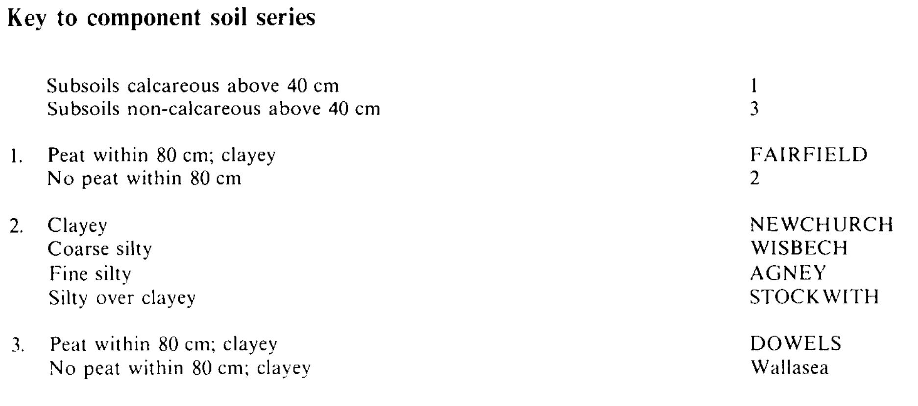
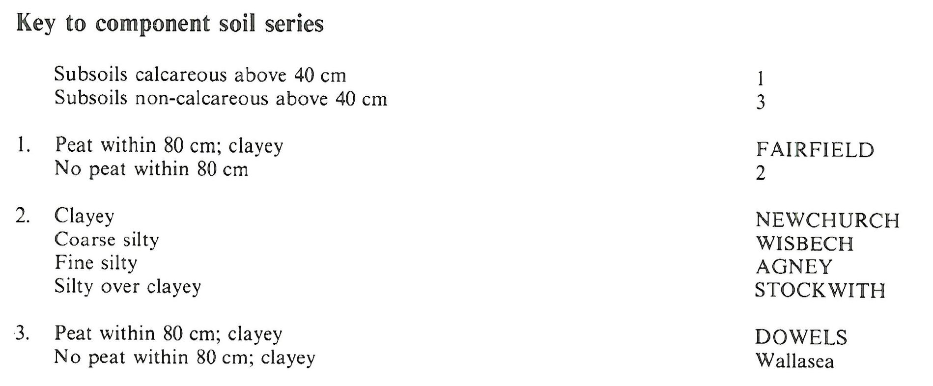
Once tidal marsh, the association is found mainly in the Fens west and south of Wisbech, but also in Romney Marsh, Kent. The stoneless marine alluvium in which the soils are formed was deposited chiefly during a marine transgression between 500 B.C. and 500 A.D., and rests on peat usually at a depth of less than a metre. The peat, which is thicker in Romney Marsh than in the Fens, in turn covers a lower marine clay. The land is flat and everywhere below 3 m O.D., but there is some microrelief in the form of ridges. representing creeks in the former marsh. The soils were originally more or less permanently waterlogged but they are drained nowadays by pumps. The main soil series is the non-calcareous clayey over peat Dowels series, pelo-alluvial gley soils, which together with some similar Wallasea soils found where the clay is thicker, occur on low ground between the creek ridges. Similar but calcareous clayey over peaty and clayey soils, Fairfield and Newchurch series respectively, both pelo-calcareous alluvial soils, also occur in these positions, mainly in Romney Marsh. Deep calcareous silty soils are found on the ridges: principally coarse silty Wisbech series, fine silty Agney series and silty over clayey Stockwith series-all calcareous alluvial gley soils. The clayey soils locally have large amounts of exchangeable sodium and magnesium in their subsoils and have a poor soil structure.
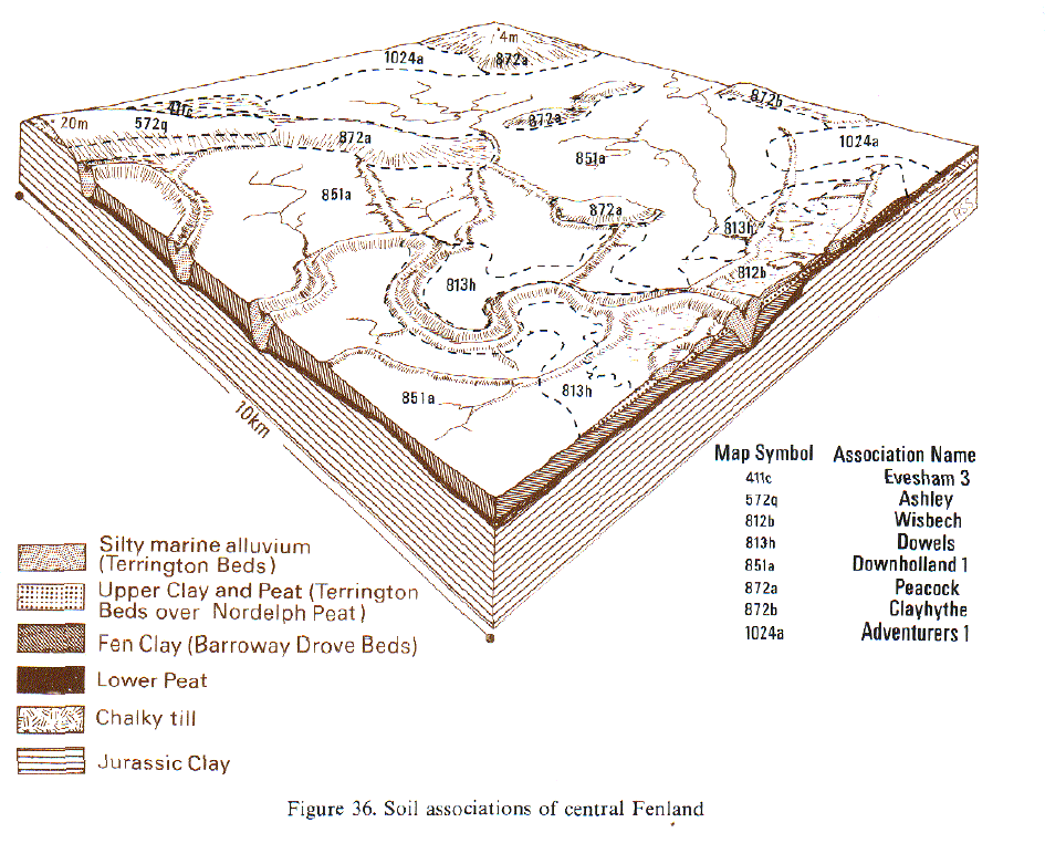
In the Fens the association is found on the inland margin of the marine transgression where alluvium meets the peatland. The peat beneath the alluvial clay is locally less than 60 cm thick and is as thin as 20 cm in places. Occasionally the alluvium rests directly on the lower Fen clay. Dowels soils pass gradually to Adventurers' series at the junction with the peatland and here the subsoils of some thick peat soils are extremely acid. The creek ridges, known as rodhams, have crests up to 1.5 m above the general level, and are locally aligned in parallel, indicating human control at the time the alluvium was deposited.
In Romney Marsh the association forms the lowest land in the marsh, the ground between the ridges being less than 1 m O.D. in places. The Dowels series, which was partly mapped as the former Appledore series, is over peat that is rarely less than 60 cm and may be as much as 2.5 m thick. The groundwater is locally brackish and the subsoils then have large exchangeable sodium and magnesium contents.
Soil Water Regime
As the land has long been arterially drained, the moderately permeable Wisbech and Agney soils on the raised rodhams are well drained (Wetness Class I). The peat beneath the clayey soils of the intervening low ground is permeable and carries water laterally to field ditches, but the clayey upper horizons of Dowels, Fairfield, Newchurch and Wallasea series are slowly permeable so that they are occasionally or seasonally waterlogged (Wetness Classes II and III). Oxidation and wasting of the peat, reducing its thickness, can cause surface subsidence and future drainage difficulties.
The silty Wisbech and Agney soils are very water retentive and are not droughty for arable crops, but the less retentive Newchurch and Wallasea soils are slightly droughty for cereals, moderately droughty for potatoes and very droughty for grass. The dominant Dowels soils are intermediate in character.
Cropping and Land Use
The field capacity period in a normal year is about three months, from mid-December to mid-March, so there are normally ample opportunities for autumn and spring cultivations even for the difficult-to-work clayey Dowels, Fairfield, Newchurch and Wallasea soils, which however have restricted periods suitable for landwork in wet springs. There is a correspondingly longer time available for landwork on Stockwith, Romney and Agney soils. The dominant heavy soils are found in most fields so the timing of landwork is usually determined by their condition. Winter cereals, mainly wheat, are the main crops. Spring barley, potatoes, mainly maincrop, and field vegetables, chiefly peas, are common and sugar beet is also grown. Yields are locally affected by very acid peat subsoils.
The land in Romney Marsh is mainly permanent grassland carrying both sheep and cattle although there is some arable. Much of the land is difficult to drain effectively and so is unsuitable for cultivation. There are ample opportunities for traditional cultivations in autumn on the silty soils, but even where the land is drained, suitable conditions for the tillage of the extensive clay soils are limited and this controls the timing of all cultivations. In wet years, opportunities for spring landwork are negligible. Where the clayey soils contain large amounts of exchangeable sodium the structure is poor and careful management is necessary to avoid damage. Available phosphorus and potassium are low in the subsoils of the silty soils and manganese deficiency may occur in crops on the heavy textured alkaline soils affected by high groundwater.
0813h Dowels
Distribution Map
 |
Note that the yellow shading represents a buffer to highlight the location of very small areas of the association.
Keys to component soil series
Eastern Region
 |
South Eastern Region
 |
Typical Landscapes
Eastern Region
 |
All information Copyright, Cranfield University © 2025
Citation: To use information from this web resource in your work, please cite this as follows:
Cranfield University 2025. The Soils Guide. Available: www.landis.org.uk. Cranfield University, UK. Last accessed 25/04/2025
