
Soil Associations
0814c NEWCHURCH 2
Soil and site characteristics
Deep stoneless mainly calcareous clayey soils. Groundwater controlled by ditches and pumps. Flat land. Risk of flooding in places.
Geology
Marine alluvium
Cropping and Land Use
Permanent grassland with winter cereals in Somerset and Avon; cereals, sugar beet, potatoes and field vegetables in the Eastern Region.
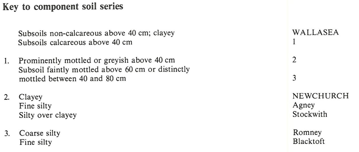
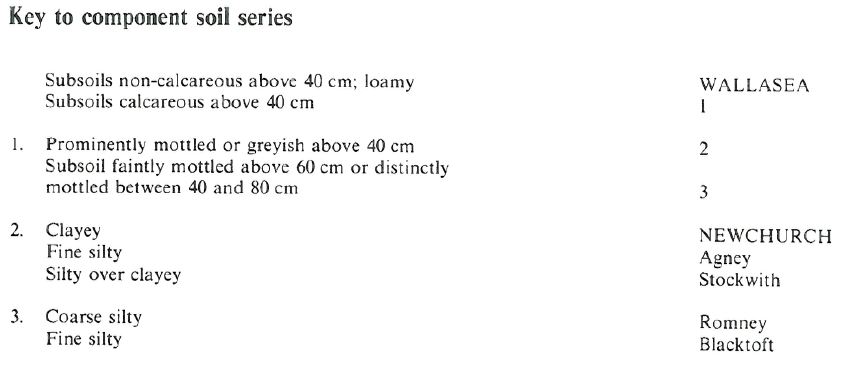
Component soil series
| Subgroup | Series name | Percentage | WRB 2006 link |
|---|---|---|---|
| 8.14 | NEWCHURCH | 60% | Clayic Fluvic Calcaric Gleysols |
| 8.13 | WALLASEA | 30% | Clayic Fluvic Eutric Gleysols |
Covers 777 km2 in England and Wales
Soilscapes Classification
| 21 |
Loamy and clayey soils of coastal flats with naturally high groundwater |
0814c NEWCHURCH 2
Detailed Description
This association is extensive on stoneless clayey marine alluvium in Humberside, lincolnshire, Norfolk, Essex, Kent, Sussex, Somerset, Glouchestershire, Avon and south Wales. The Newchurch series, which belongs to the pelo-calcareous alluvial gley soils, dominates the association which also contains non-calcareous clayey Wallasea series and, locally, calcareous silty Agney, Romney and Blacktoft series and silty over clayey Stockwith series. These soils were formerly mapped by Crampton (1972) as the Wentlloog series and cover some 67 km² from the Caldicot Levels in Gwent along the Severn to Cardiff. The Newchurch series is dominant with some Wallasea but few other soils.
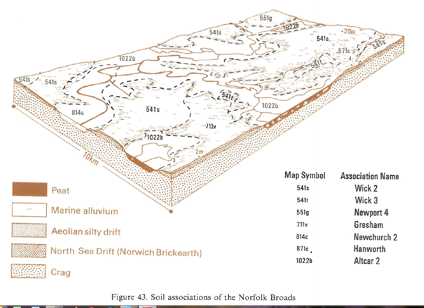
In Eastern England the soil pattern is relatively simple because there are usually few creek ridges, which in other associations on marine alluvium carry coarse or fine silty soils. Locally in Norfolk, sulphuric soils occur where the clay thins out over peat at the margins of the spread of alluvium. The association occurs near Great Yarmouth in the extensive marshland bordering the rivers Thurne, Bure, Yare and Waveney. It is also present in north-east Lincolnshire between Tetney and South Somercotes. Here the alluvium extends westwards up narrow valleys in the wide low-lying till plain known locally as the Middle Marsh and small patches of loamy, seasonally waterlogged, Holderness soils are included where the alluvium is thin over till.
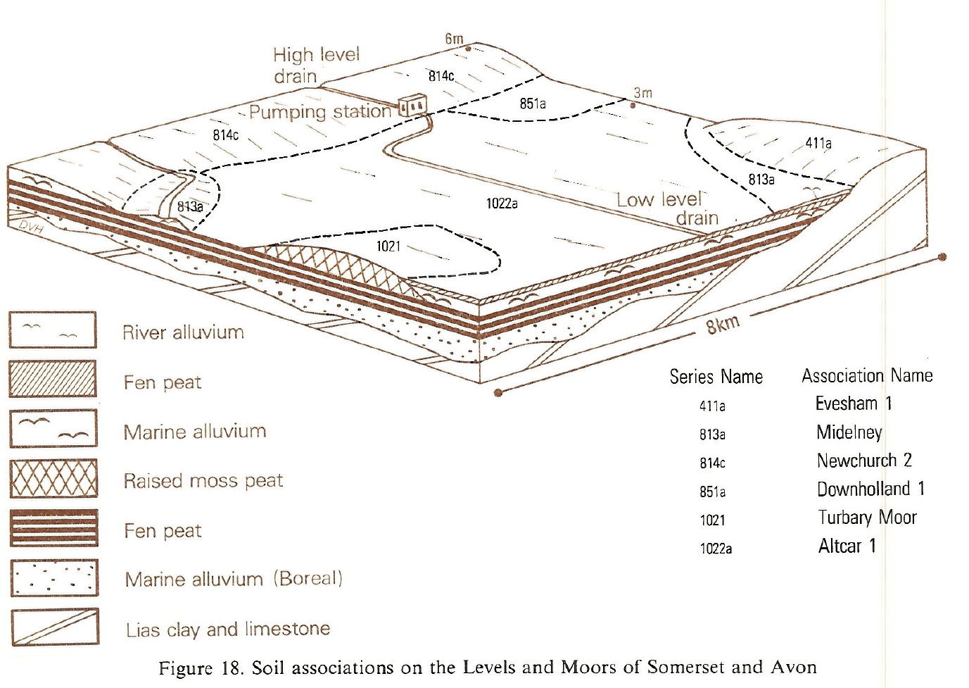
In Somerset, Avon and Gloucestershire the association is extensive on the Levels formed by a broad coastal belt of marine alluvium, and matched on the opposite side of the Severn by similar deposits in Gwent. In Somerset the Levels are separated from the shore by a line of dunes and elsewhere usually by unenclosed saltings. The land is flat and nearly all deposits are clayey so the soil pattern is simple. It is dominated by Newchurch soils, with Wallasea soils where the upper layers are decalcified. Both soils were included in the former Wentlloog series. Low levees of Blacktoft soils are found, mainly where small streams or pills flow out into the Severn. Small areas of Downholland soils with more strongly mottled upper layers occupy ground once regularly flooded in winter but now largely improved by drainage.
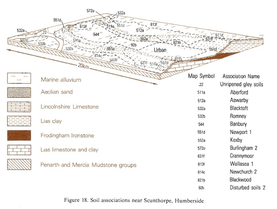
In Humberside the association occurs to the east of Sunk Island, near Hedon, at Walling Fen and along the south bank of the Humber estuary from Barton-Upon-Humber to beyond Cleethorpes. The total extent is approximately 117 km².
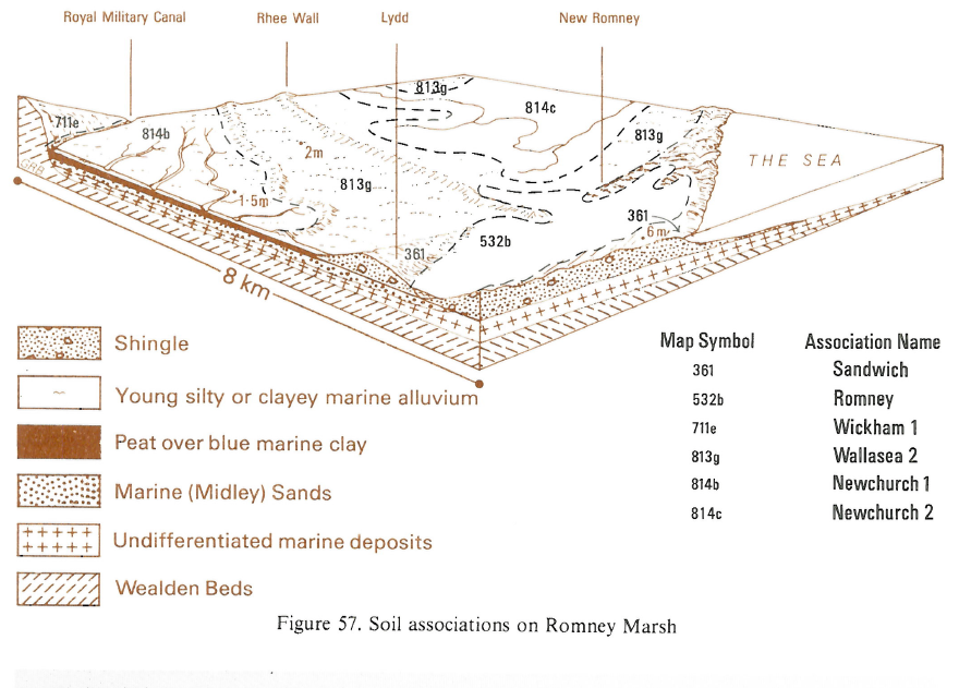
The soil pattern is relatively simple because there are usually few creek ridges but in Romney Marsh, where the soils occur on the "New" marshland, as described by Green (1968), there are more silty over clayey Stock with soils than elsewhere. On undrained land, as in the Pevensey Levels, there are grassland soils with thin humose topsoils and some Downholland, Dowels and Chatteris soils.
Soil Water Regime
The land is very low-lying and protected from high spring tides by sea-defences. Most of the soils are at least moderately permeable but field drainage systems and pump drainage are necessary for efficient groundwater control. These soils are usually waterlogged for long periods in winter (Wetness Class IV) particularly where field drainage systems have not been installed and where the arterial system depends on gravity drainage. The soils are non-droughty for arable crops and grass. Where control is effective, as in parts of Lincolnshire and Norfolk, Newchurch and Wallasea soils are waterlogged in winter only occasionally (Wetness Class II) but elsewhere they are seasonally waterlogged (Wetness Class III). The soils are highly water retentive and are non-droughty for cereals, but moderately droughty for grass.
Cropping and Land Use
Though there is some evidence that the Romans grew cereals here after reclaiming the land from the Severn estuary, it is now mainly used for grazing. The land poaches easily in the autumn and spring, especially where undrained. Field drainage systems are necessary for successful arable use. Recently some land has been drained and about one-tenth is again in arable use. Even after drainage there is serious risk of structural damage during cultivations which need to be timed carefully to coincide with drier soil conditions.
In Eastern England with good groundwater control these clayey soils have a lengthy period in autumn with good conditions for cultivations. The spring period affords few opportunities and landwork in a wet spring is very restricted. Structural damage is common under arable use and harvesting of root crops is difficult in wet years. In Lincolnshire, cereals with potatoes, sugar beet and field vegetables are the main crops but much of the land in Norfolk is in permanent grassland for summer grazing. Here, high groundwater levels are maintained to sustain grassland production and provide water-filled ditches as stock-proof field boundaries. Only one-fifth of the Norfolk Marshes is under cereals, partly because of the grazing tradition and partly because of the risk of flooding at harvest. Change to arable use usually needs local agreement on lowering the height of maintained water levels. Mixed land use is sometimes achieved by temporarily blocking the ends of field ditches. Grassland yields in Lincolnshire are small because of droughtiness.
In Humberside, cereals with potatoes, sugar beet and field vegetables are the main crops.
The grazing tradition survives in the mild, moist climate bordering the Bristol Channel, where grassland yields well and good crops of hay and silage can be taken. However, the fields poach easily in the autumn and spring, especially undrained land suited to seasonal grazing only. Winter cereals are grown on some farms following the installation of field drainage systems but there is great risk of structural damage during cultivation and occasional winter floods can cause patchy germination.
Potassium and magnesium levels are generally satisfactory but phosphorus levels are often low when poor-quality grassland is brought into arable use. Manganese deficiency sometimes occurs on Newchurch soils.
0814c NEWCHURCH 2
Distribution Map
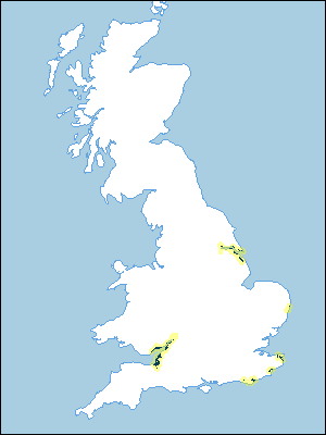 |
Note that the yellow shading represents a buffer to highlight the location of very small areas of the association.
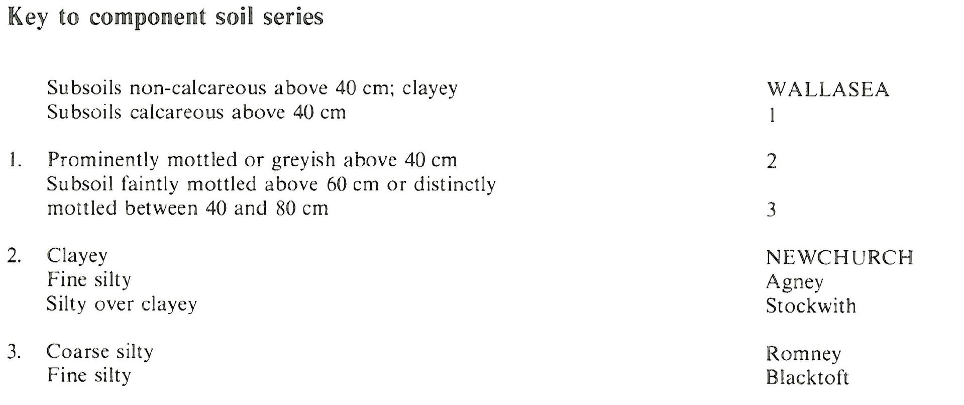
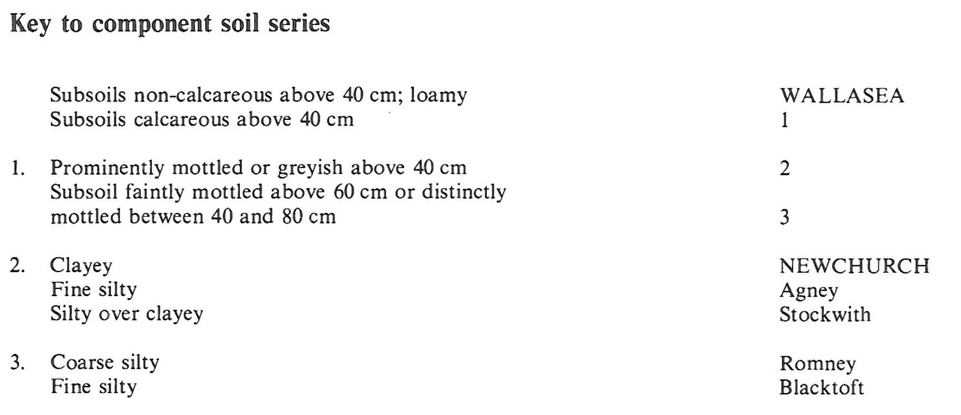
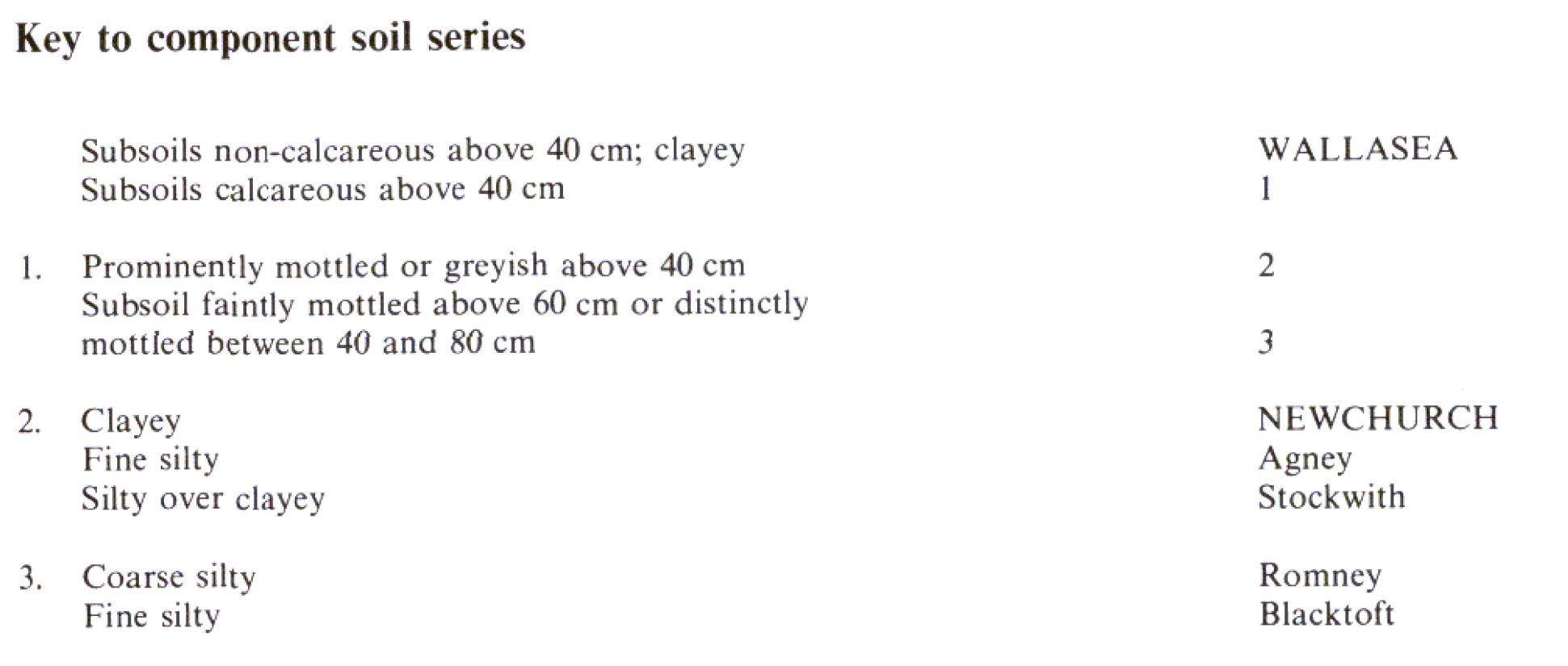
Keys to component soil series
South Eastern Region
 |
South Western Region
 |
Wales
 |
Eastern Region
 |
Northern Region
 |
Typical Landscapes
South Western Region
 |
South Western Region
 |
Eastern Region
 |
Eastern Region
 |
Northern Region
 |
South Eastern Region
 |
All information Copyright, Cranfield University © 2024
Citation: To use information from this web resource in your work, please cite this as follows:
Cranfield University 2024. The Soils Guide. Available: www.landis.org.uk. Cranfield University, UK. Last accessed 27/07/2024
