Soil Associations
0821a EVERINGHAM
Soil and site characteristics
Deep stoneless permeable fine sandy soils some with bleached subsurface horizon. Groundwater controlled by ditches. Risk of wind erosion.
Geology
Aeolian sand
Cropping and Land Use
Cereals, potatoes and sugar beet.
Component soil series
| Subgroup | Series name | Percentage | WRB 2006 link |
|---|---|---|---|
| 8.21 | EVERINGHAM | 60% | Arenic Mollic Gleysols |
| 5.52 | KEXBY | 15% | Eutric Endogleyic Arenosols |
| 6.41 | HOLME MOOR | 10% | Densic Endogleyic Albic Carbic Podzols |
| 8.21 | BLACKWOOD | 10% | Arenic Mollic Gleysols |
Covers 214 km2 in England and Wales
Soilscapes Classification
| 15 |
Naturally wet very acid sandy and loamy soils |
0821a EVERINGHAM
Detailed Description
This association is dominated by stoneless fine sandy permeable soils in aeolian sand which overlies clay in many places. Where undrained pale brown and grey subsoil colours indicate that many of the soils are waterlogged almost to the surface in winter. In some districts groundwater levels have been lowered by regional drainage. The association occurs widely in the Vale of York and is also found in west Wales. Altitude varies from sea level in Wales to 30 m O.D. near Selby. The most common soil is the fine sandy Everingham series, which belongs to the typical sandy gley soils, with the Kexby series, gleyic brown sands, on slightly higher ground. The Holme Moor series of typical gley podzols is rarely found in Wales. Other soils include the Blackwood and Ollerton series, Adventurers', Gilberdyke and Isleham series.
The soils cover 178 km², particularly around York and Selby and eastwards to Holme¬on-Spalding-Moor. Kexby soils occur in slightly elevated areas and the Holme Moor series on the highest sites. Medium sandy Blackwood soils occur occasionally within the association, more commonly where it adjoins the Blackwood association. Other minor soils include the Adventurers' , Gilberdyke and Ollerton and Isleham series.
Soil Water Regime
In Wales, most of the soils are waterlogged almost to the surface for much of the year (Wetness Class V) and winter rain quickly leads to flooding. These permeable soils respond well to drainage by pipes and field ditches, provided that the water levels in the ditches can be lowered. Fluctuating groundwater levels used to be the outstanding feature of the main soils of this association before the land was effectively drained. In the Vale of York however, water levels are now lower and most soils are in Wetness Classes I or II. These permeable soils respond well to drainage by pipes and field ditches. Silting of drains occurs but can be overcome by the use of filter-wrapped pipes. In spite of lowered groundwater levels, available water in the main soils still generally exceeds the moisture deficits to be expected under most crops in the Vale of York. Grass, however, is liable to suffer moderate droughtiness in an average year while in dry years droughtiness affects most crops to varying degrees, grass suffering severely.
Cropping and Land Use
These easily worked stoneless soils are well suited to a wide range of arable and horticultural crops in the drier parts of England, but in west Wales much land remains undrained as rough pastures. Locally land drainage has been improved by ditching. There are also Sites of Special Scientific Interest, which contain diverse wetland vegetation and provide winter refuge for wildfowl. All the soils are acid and infertile under natural conditions. Regular dressings of lime and fertilizer will produce good yields however. Deficiencies of trace elements, particularly manganese, can be induced by excessive liming. Most of the soils are well suited to horticulture, particularly ornamental plants such as shrubs, conifers, heathers and herbaceous plants which grow well in acid soil. Trees grow well where the groundwater level is controlled, good yields being obtained from small coniferous plantations in several parts of the Vale of York. Planting is mainly of Scots and Corsican pine with some sycamore. Where groundwater levels are high, trees will be shallow rooted and thus liable to damage by wind. Silver birch grows well in these conditions but has little commercial value.
0821a EVERINGHAM
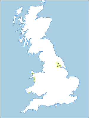
Distribution Map
 |
Note that the yellow shading represents a buffer to highlight the location of very small areas of the association.
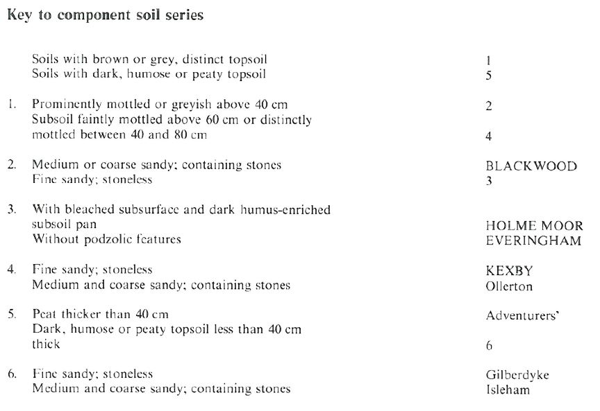
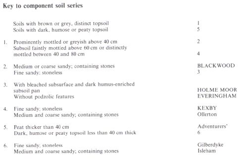
Keys to component soil series
Northern Region
 |
Wales
 |
All information Copyright, Cranfield University © 2025
Citation: To use information from this web resource in your work, please cite this as follows:
Cranfield University 2025. The Soils Guide. Available: www.landis.org.uk. Cranfield University, UK. Last accessed 25/04/2025
