
Soil Associations
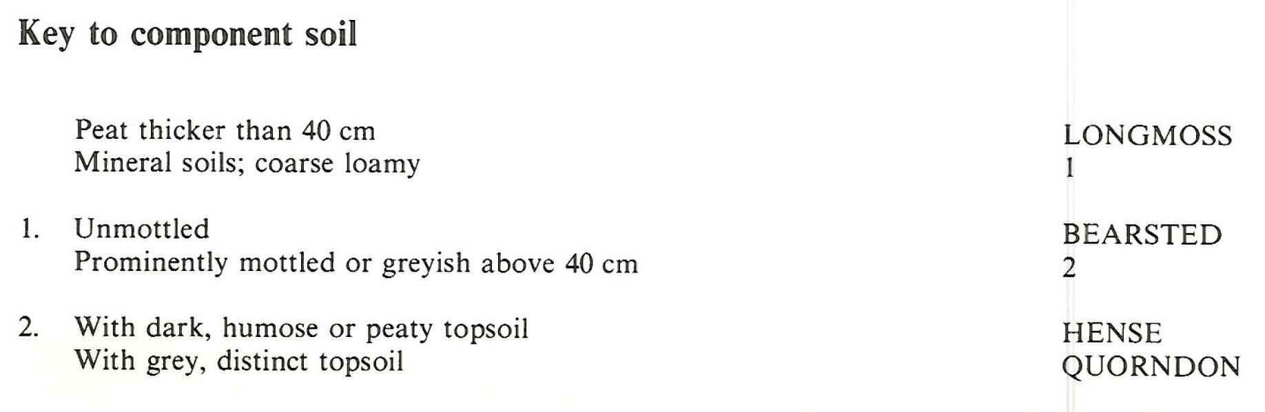
0871b HENSE
Soil and site characteristics
Permeable coarse loamy soils mainly with a humose or peaty surface horizon affected by groundwater. Peat soils and some well drained coarse loamy soils locally.
Geology
Drift from Cretaceous sand and loam
Cropping and Land Use
Wetland, woodland and wet moorland habitats; some coniferous woodland and improved grassland.
Component soil series
| Subgroup | Series name | Percentage | WRB 2006 link |
|---|---|---|---|
| 8.71 | HENSE | 50% | Dystric Histic Gleysols |
| 8.31 | QUORNDON | 20% | Dystric Gleysols |
| 10.11 | LONGMOSS | 20% | Ombric Fibric Histosols |
| 5.41 | BEARSTED | 10% | Eutric Cambisols |
Covers 83 km2 in England and Wales
Soilscapes Classification
| 16 |
Very acid loamy upland soils with a wet peaty surface |
0871b HENSE
Detailed Description
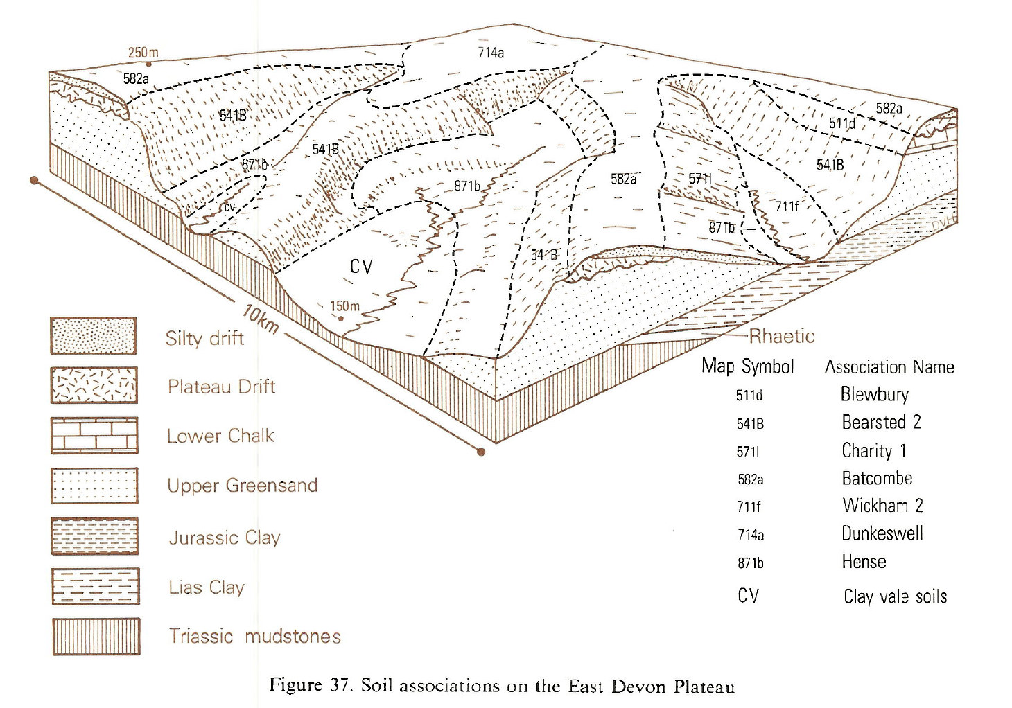
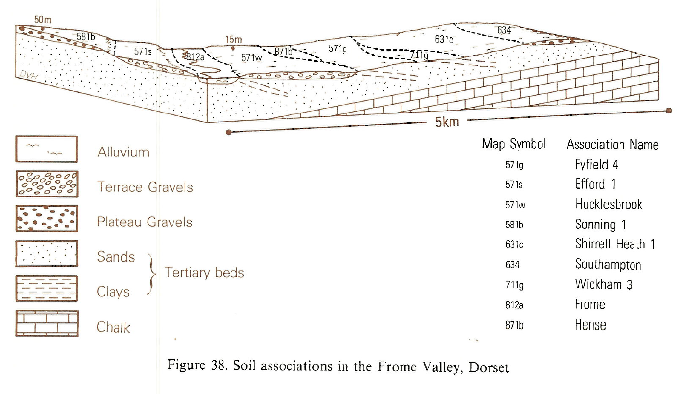
The Hense association is made up of coarse loamy, glauconitic humic gley soils, Hense series, raw oligo-fibrous peat soils, Longmoss series, and coarse loamy typical cambic gleys of the Quorndon series, formerly described as Odle series. The soils have fine sandy loam substrates and are waterlogged for long periods by groundwater from spring flushes. Hense series has humose or peaty surface layers, the peat thickening with increasing soil wetness to exceed 40 cm in the Longmoss series; the drier Quorndon soils have a non-peaty surface horizon. Hense and the deeper Longmoss profiles have greenish or bluish subsoils, known in east Devon as greensand or spewsand, distinguishing them from the foxmould sand of drier ground. The unit is mapped along a prominent springline at the scarpfoot of the Upper Greensand outcrop which skirts the flat-topped hills of east Devon and south-west Somerset. The underlying impermeable Keuper Marl and Lias clay hold up water in the Greensand, and the soils are formed on a bench of slumped Greensand several metres thick or on Head which has been soliflucted downslope into the adjacent vales. In places, over the Lias clay in particular, hummocky ground, with rotational landslips, supplants the bench. The springline broadens in valley heads but narrows around spurs. The ground rises from near sea level at Lyme Regis to 290 m O.D. on the Blackdown Hills and much is in rough pasture, scrub woodland, heath or Molinia moorland. Some well drained coarse loamy Bearsted soils are included.
Longmoss peat soils are most common on north- and west-facing slopes where springs are most frequent and have the strongest flow. The distribution and flow of springs depends on a number of factors, such as extent of catchment on the adjacent plateau, dip of the nearly horizontal Greensand and precise position on the scarp slope; the flow is weakest on spurs and strongest in combe and valley heads. Wettest sites tend to be at the back of the bench near the scarp, the downslope bluff being occupied by drier Quorndon soils, which occupy most of the bench around spurs. The soils tend to be more stony with chert downslope from the bluff. The unit has close geographical relationships with the well drained Bearsted association on the steep Greensand scarp, the abrupt boundary between the two following a line of spring-sapping. Some Bearsted soils are incorporated within the Hense association where scale prevents their separate delineation.
Soil Water Regime
The Hense and Longmoss series are kept permanently waterlogged by springs (Wetness Class VI), the subsoil instability making drainage improvement unreliable and short lived. Quorndon soils are seasonally waterlogged (Wetness Class IV) and although easier to drain effectively are similarly unstable. Groundwater flow is the main feature of the hydrology of both Hense and Longmoss series. The combination of saturated state and slope means that run-off is rapid. Permeability of the drier Quorndon soils is greater but steep gradient maintains run-off. Without drainage the soils are little affected by drought. In general these fine sandy loam soils have favourable available water capacities, about 160 mm, considerably more than crops need in a moist climate.
Cropping and Land Use
Having water retentive topsoils, wet or waterlogged subsoils, and uneven slope, much of this land is under rough woodland with alder and willow, Molinia moorland or wet heathland. There are a few conifer plantations. On agricultural land rushy permanent pasture predominates with better grassland and occasional arable crops confined to Quorndon soils, which when drained, are moderately easy to work. In one year in four, in wetter districts like Honiton, opportunities for tillage are very limited, but in drier places nearer the coast there is more scope. Hense and Longmoss series have sufficient moisture reserves to sustain good growth of grass, but they are easily poached by stock and damaged by traffic. Drained Quorndon soils are well suited to pasture, yielding well with little risk of damage or crop loss by poaching. Wetness limits forestry on Hense soils, by restricting roots and giving poor trafficability. The extensive wet moors, heaths and woods complement diverse habitats on the adjacent scarps to provide for wildlife and game, at the same time adding much to the scenic attraction of western Wessex.
0871b HENSE
Distribution Map
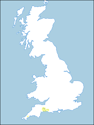 |
Note that the yellow shading represents a buffer to highlight the location of very small areas of the association.
Keys to component soil series
South Western Region
 |
Typical Landscapes
South Western Region
 |
South Western Region
 |
All information Copyright, Cranfield University © 2025
Citation: To use information from this web resource in your work, please cite this as follows:
Cranfield University 2025. The Soils Guide. Available: www.landis.org.uk. Cranfield University, UK. Last accessed 25/04/2025
