
Soil Associations
0541e CREDITON
Soil and site characteristics
Well drained gritty reddish loamy soils over breccia, locally less stony. Steep slopes in places.
Geology
Permian and Carboniferous reddish breccia
Cropping and Land Use
Dairying and stock rearing; cereals and roots: some horticultural crops.
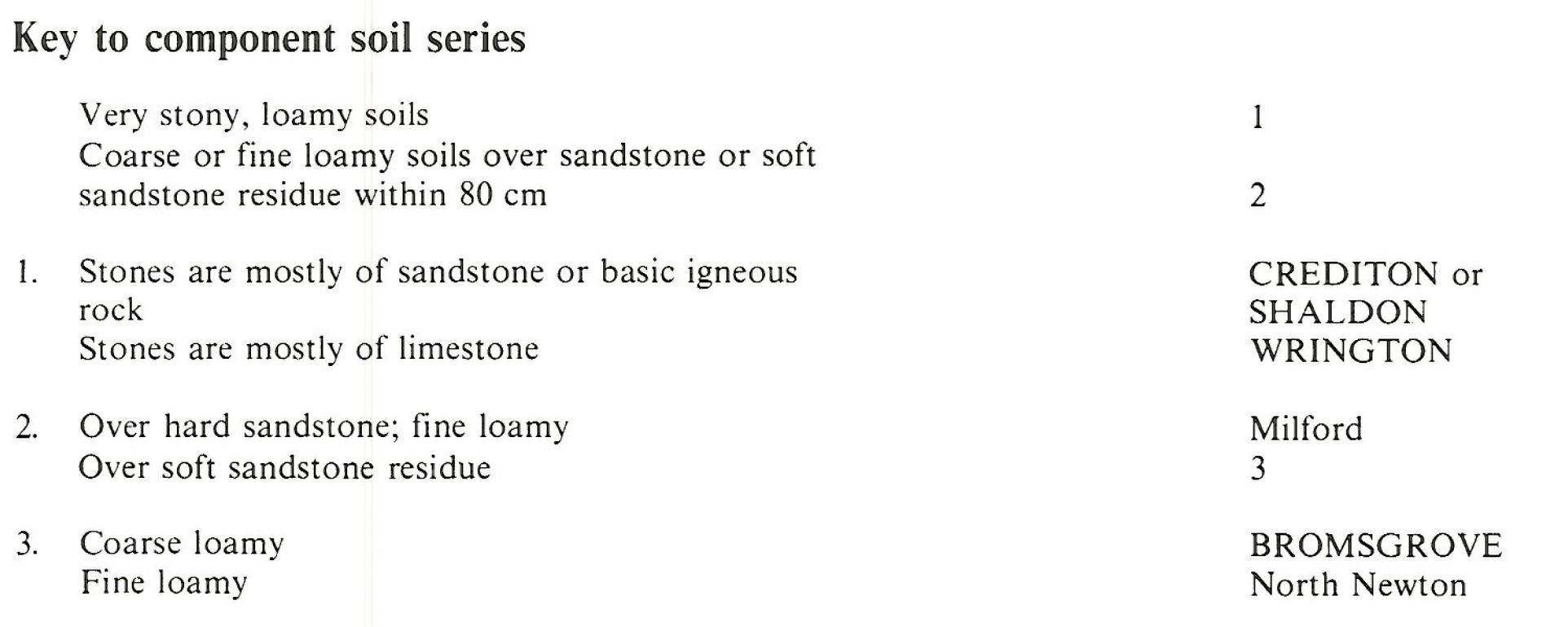
Component soil series
| Subgroup | Series name | Percentage | WRB 2006 link |
|---|---|---|---|
| 5.41 | CREDITON | 40% | Eutric Chromic Endoleptic Cambisols |
| 5.71 | SHALDON | 20% | Chromic Skeletic Luvisols |
| 5.41 | WRINGTON | 20% | Chromic Skeletic Cambisols |
| 5.41 | BROMSGROVE | 10% | Eutric Chromic Endoleptic Cambisols |
Covers 410 km2 in England and Wales
Soilscapes Classification
| 6 |
Freely draining slightly acid loamy soils |
0541e CREDITON
Detailed Description
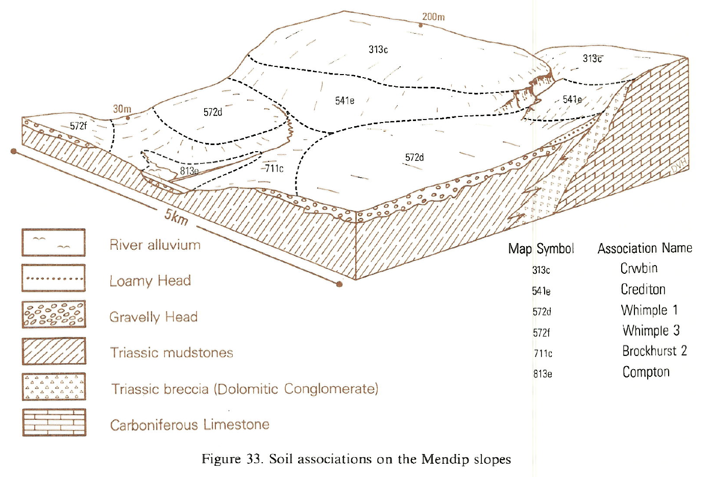
Very stony loamy typical brown earths of the Crediton and Wrington series and typical argillic brown earths of the Shaldon series are mapped as the Crediton association. They are part of the well-known red land of Devon, occupying the country on Permo-Triassic breccias and conglomerates running northwards from Torbay into Somerset, with a finger extending westwards through Crediton. In Avon the association fringes the Mendip Hills, while in Worcestershire patches occur on the Clent Breccia. The underlying rocks are accumulations of coarse grit and stones, in a finer, variably-cemented matrix. The lithology of the constituent stones reflects that of older pre-Permian rocks nearby. Near Exeter and in mid-Devon they are derived from basic igneous rocks and Carboniferous sandstones, near Torbay Devonian limestone is a distinctive constituent, while around the Mendips dolomitic limestone predominates. The landscape is usually one of rolling hills with frequent steep valleys and hillsides, rising from sea-level around the Teign estuary to over 250 m O.D. between Tiverton and Crediton. The soils are red, very stony and mainly well drained sandy silt loamy or clay loarns, with weakly differentiated horizons. Crediton series occupies almost half the land with much of the remainder being Shaldon series with its clay-enriched subsoil. Wrington series is distinguished where there are limestone fragments in the underlying breccia. Where the parent rock contains fewer stones Bromsgrove series occurs.
The Crediton series typically contains a mixture of angular basic igneous stones and Carboniferous sandstone fragments, but north and east of Crediton Clayden (1971) recognized a phase with a predominance of rounded sandstone over the Cadbury Conglomerate, close to the Carboniferous Sandstone outcrop. Some soils on sharply convex brows are truncated, with hard breccia close to the surface. Quantity as well as type of stone varies, the Crediton, Shaldon and Wrington series being very stony, with at least 35 per cent stones, and having a local reputation as sharp land. Between Exeter and Haldon many soils contain very small stones and they are appreciably more gritty. Wrington series which overlies limestone breccia or conglomerate around the Mendips and south of the Teign estuary, was mapped in detail by Findlay (1965) and Clayden (1971). Elsewhere Wrington soils are restricted to small outcrops of calcareous breccia near Wiveliscombe and Luccombe in west Somerset, and Sampford Peverell and Exbourne in Devon. Clayden (1971) mapped Shaldon series separately from Crediton series but recognized that Shaldon soils were present in the Crediton delineations. This intermixing continues elsewhere, particularly into west Somerset. Less stony Bromsgrove, Milford and North Newton soils occur on interbedded soft sandstones in the breccias, such as the Knowle Sandstone west of Crediton. Around the Haldon Hills, drift from the Greensand gives rise to loamy brown soils with common but limited gleying, caused by flushes from springs. Clayden (1971) mapped these as Mamhead Complex and Rixdale series.
Soil Water Regime
Crediton and Wrington series are permeable and well drained (Wetness Class I). The presence of ferri-manganiferous deposits in some more clayey profiles of the Shaldon series suggests occasional waterlogging (Wetness Class II), and frequent ill-timed working reduces porosity and increases soil wetness. Excess winter rain readily passes through into the permeable substrata.
Cropping and Land Use
Most of the land is used for mixed arable and grassland, although about a quarter, on steep slopes, is under permanent pasture, rough grazing or woodland. As well as cereals, 'redland' swedes are grown for human consumption or for folded sheep. There is a strong horticultural tradition on the steep land around Torbay but this has declined in recent years, only potatoes showing a small increase in area. The loamy texture and good natural drainage of these soils allows them to be worked easily and trafficked at all but the wettest times. Heavy winter rain causes slaking and capping of cultivated soil, particularly where organic matter content is low on perennially arable land, and rill erosion occurs especially on slopes worked up and down the gradient. In places steep or awkward slopes preclude efficient arable farming. Stoniness causes more than usual wear on implements and tyres and there are problems with mechanized harvesting. Profile available water is also reduced by stones and much of the association is slightly droughty for cereals, with potatoes and grass more seriously affected. Under grassland the soils have the advantage of limited risk of poaching even well into autumn but this has to be set against their susceptibility to drought.
Where steepness of slope limits intensive agriculture, woodland is an alternative. Free drainage and the loamy texture of Crediton soils encourage vigorous weed growth which with droughtiness, restricts the choice of suitable tree species. Elsewhere, as on the overcliff between Dawlish and Torbay, rough pasture on steep land has its scenic importance in a district of considerable natural beauty visited by many thousands of people annually.
0541e CREDITON
Distribution Map
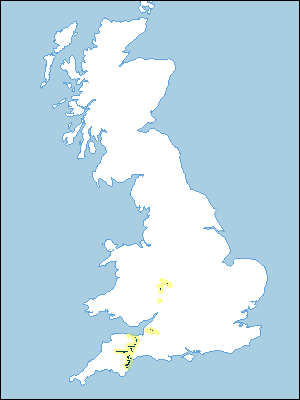 |
Note that the yellow shading represents a buffer to highlight the location of very small areas of the association.
Keys to component soil series
South Western Region
 |
South Eastern Region
 |
Typical Landscapes
South Western Region
 |
All information Copyright, Cranfield University © 2025
Citation: To use information from this web resource in your work, please cite this as follows:
Cranfield University 2025. The Soils Guide. Available: www.landis.org.uk. Cranfield University, UK. Last accessed 25/04/2025
