
Soil Associations
0541i MUNSLOW
Soil and site characteristics
Well drained coarse silty soils over siltstone. Occasional similar but fine silty and coarse loamy soils. Risk of water erosion.
Geology
Silurian siltstone
Cropping and Land Use
Cereals and widespread short term grassland with stock rearing; deciduous woodland on steep slopes.
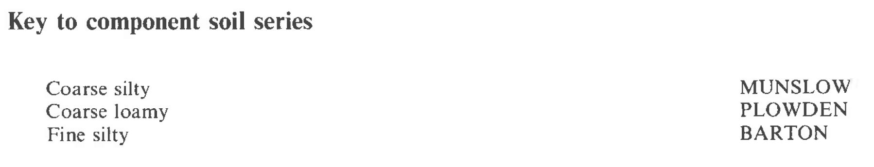
Component soil series
| Subgroup | Series name | Percentage | WRB 2006 link |
|---|---|---|---|
| 5.41 | MUNSLOW | 45% | Eutric Endoleptic Cambisols |
| 5.41 | BARTON | 20% | Eutric Endoleptic Cambisols |
| 5.41 | PLOWDEN | 20% | Eutric Endoleptic Cambisols |
Covers 164 km2 in England and Wales
Soilscapes Classification
| 6 |
Freely draining slightly acid loamy soils |
0541i MUNSLOW
Detailed Description
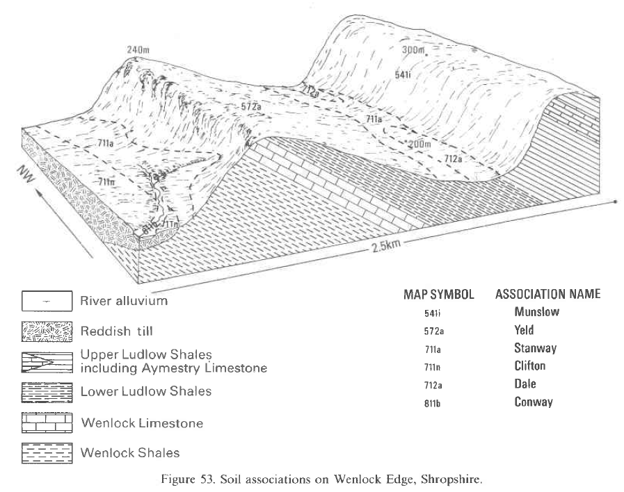
The Munslow association, extensive in south Shropshire and north Herefordshire is developed on hard Lower Palaeozoic siltstones with subordinate fine grained sandstones. It covers 159 km² mainly on the dipslope formed on Silurian strata, stretching from Shobdon Hill to Much Wenlock and in broken country east of Church Stretton underlain by Ordovician rocks. The olive-green and buff siltstones and fine sandstones are mostly decalcified but contain occasional thin platy limestone bands. Rare beds of silty shale also occur and the whole weathers to form moderately deep, stony, very porous profiles. Coarse silty typical brown earths of the Munslow series predominate on the main siltstones but similar coarse loamy Plowden soils are well represented where the parent material contains interbedded fine sandstones. Argillaceous siltstones give fine silty Barton soils (typical brown earths) and there are small inclusions of Wilderhope and Yeld series associated with limestones and silty shales respectively. This is a very uniform association with typical brown earths covering almost all of the land. The distribution of the three main series depends on the lithology of the thinly bedded underlying rocks. The land ranges in height from approximately 100 to over 300 m O.D. west of Munslow, and usually slopes at more than 7 degrees. Slopes over 16 degrees are restricted to the cuesta scarp. Soils on the upper dipslope are often transitional in character to brown podzolic soils. There is widespread evidence of erosion in the build-up of soil on the upslope side of hedgerows and the presence of bedrock within plough depth on eroded brows. In most soils bedded siltstone or sandstone usually occurs between 40 and 70 cm depth although deeper colluvial soils occur in some valley bottoms or on scarp-foot sites. These deeper profiles are usually associated with coarse silty gleyic brown earths, formerly described as Shipton series by Hodgson (1972), particularly around spring sites.
Soil Water Regime
Munslow, Barton and Plowden series are well drained (Wetness Class I). Surplus winter rainfall passes downwards through these permeable soils. Soils with bedrock deeper than about 75 cm are non-droughty for all crops but where soils are shallow with bedrock between 50 and 75 cm depth they are slightly droughty under grass. Shallower soils are moderately droughty for all crops.
Cropping and Land Use
Almost half the land is under woodland, the remnants of the former Mocktree Forest and Bringewood Chase. Much of the rest is in arable use but steep slopes carry permanent grass or rough grazing. The main arable crop is barley and sheep and beef rearing are important on the grasslands. Seed potatoes, which have recently been introduced because of the increasing need to find disease-free sites are particularly successful on the deep soils. The soils are easily cultivated and produce a good tilth, but their typically high silt and fine sand contents make them susceptible to capping and subsequent erosion. The risks are greatest during heavy summer storms after a dry spell, especially on fields under long-term cultivation where organic matter levels are low and surface structure weak. Both sheet and gully erosion, the latter a particular risk with potatoes, are common. Rapid permeability and small retained water capacities of surface horizons ensure that cultivations can progress during rain-free periods in the winter and early spring. The average field capacity period is less than 200 days and the calculated work days indicate that spring working is feasible, except in wet years, without incurring structural damage. Under woodland most of the soils are strongly acid, though in places where the underlying siltstone is calcareous there are slightly acid soils. The pH under farmland is variable depending on land use but to counteract the rapid leaching and natural acidity regular applications of lime are necessary. Potassium levels are usually satisfactory and trace-element problems are uncommon. Tree growth is good on Munslow soils and specimen trees are referred to by Elwes and Henry (1906) at Croft, Herefordshire. Douglas fir, especially on the deeper soils of the unit (16-22 m3/ha/year), European larch (10 m3/ha/year) and Western hemlock grow well on these soils although yield data for the latter is limited. Above 300 m Scots pine gives timber of excellent quality and has yields of 8-12 m3/ha/year even where the soils are both shallow and acid. Where the rainfall is high, Sitka spruce yields better than this and Western hemlock yields well. Oak grows well on the deeper soils but is not profitable and the profitability of sycamore and beech, which have been planted locally, is also in doubt.
0541i MUNSLOW
Distribution Map
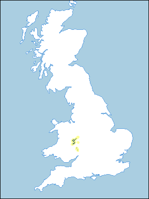 |
Note that the yellow shading represents a buffer to highlight the location of very small areas of the association.
Keys to component soil series
Midlands
 |
Typical Landscapes
Midlands
 |
All information Copyright, Cranfield University © 2024
Citation: To use information from this web resource in your work, please cite this as follows:
Cranfield University 2024. The Soils Guide. Available: www.landis.org.uk. Cranfield University, UK. Last accessed 27/07/2024
