Soil Associations
0541m SOUTH PETHERTON
Soil and site characteristics
Deep well drained silty soils some over soft rock. Risk of water erosion.
Geology
Jurassic and Cretaceous siltstone and sandstone
Cropping and Land Use
Cereals, potatoes, field vegetables and horticultural crops; dairying.
Component soil series
| Subgroup | Series name | Percentage | WRB 2006 link |
|---|---|---|---|
| 5.41 | SOUTH PETHERTON | 60% | Eutric Endoleptic Cambisols |
| 5.71 | BRIDPORT | 20% | Haplic Luvisols |
| 5.41 | ATRIM | 20% | Siltic Eutric Cambisols |
Covers 224 km2 in England and Wales
Soilscapes Classification
| 6 |
Freely draining slightly acid loamy soils |
0541m SOUTH PETHERTON
Detailed Description
Deep, predominantly well drained stoneless silty soils make up this association, they are found on soft yellowish fine sandstones and siltstones of Jurassic age. Although primarily located between Glastonbury and Ilminster in Somerset, and near Bridport in Dorset, they occur also in the Weald of East Sussex and Kent. All the soils are coarse or fine silty with abundant very fine sand and silt, and clay contents between 10 and 25 per cent. The two main soils are typical brown earths with yellowish brown weakly structured friable subsurface horizons. South Petherton series is coarse silty throughout and is found mostly on the highest beds of the Yeovil and Bridport Sand. It often occurs on the steepest land, and is largely under grass. South Petherton soils contain more fine sand than silt, have the lowest clay content of all the component soils, and soft micaceous sandstone or sand-rock is often within moderate depth. Atrim series is similar but fine silty, containing more silt and slightly more clay. Bridport soils, typical argillic brown earths, are similar to the South Petherton series, with coarse silty upper horizons, but they have finer-textured, strong-brown subsoils. On footslopes and other low-lying ground, occasionally on slopes, stagnogleyic argillic brown earths of the Curtisden series, have weakly mottled subsoils.
In Somerset and in west Dorset, these permeable soils and the underlying soft rocks are cut into by headwaters of many streams to form an undulating landscape with frequent steep slopes and conical knolls. Man-made trackways have been accentuated by erosion into characteristic holloways. Marked differences in field levels are further evidence of past erosion and current loss of topsoil can be seen in many arable fields. As a consequence of erosion there are fine and coarse silty colluvial brown earths on footslopes and behind hedge banks. Much of the higher ground is eroded and the soils have thin subsoils and weakly differentiated profiles. Ancilliary soils, are mostly derived from limestones, which cap flat-topped ridges, and include Elmton, Sherborne and Haselor series , Tetbury and Ston Easton series.
The association occurs locally in West and East Sussex. In St Leonard's Forest, east of Horsham, the soils are developed in Upper Tunbridge Wells Sand and here many thin clay seams outcrop in the minor valleys at the head of the river Arun. South Petherton soils are frequently more stony than in South West England, and coarse loamy Rivington and Bearsted soilsover hard and soft sandstones are also present. Atrim soils occupy about a tenth of the area and wetter Curtisden and Cranbrook soils are common where clay seams occur. Bridport soils, typical argillic brown earths, are not present in this region. The association is also mapped on The Plain east of Withyham.
Soil Water Regime
The main soils are permeable and well drained (Wetness Class I) and under grass they accept winter rain readily, though those on steep slopes experience some run-off. Under intensive arable use, waterlogging and surface erosion are caused by deterioration of structure and development of pans which impede water entry to the subsoil. Curtisden soils have faint mottling in the subsoil which is correlated with occasional waterlogging (Wetness Class II) in undrained soils. South Petherton, Bridport and Atrim soils have large available water capacities and crops rarely experience drought, other than permanent grass for which the soils are slightly droughty.
Cropping and Land Use
Where slope permits in south Somerset, a wide range of crops are grown on these easily worked soils. There are lengthy opportunities for autumn cultivation, though spring work is restricted, particularly in a wet season. Winter cereals are the main arable crop but maincrop and second early potatoes, maize for silage, sugar beet and vegetables, mainly brassicas, are extensively grown. Continuous arable use has caused widespread erosion, even on gentle slopes. Potato fields are particularly at risk as ridges are usually aligned downslope, so are winter cereal fields which have bare ground during autumn and early winter. Although rill erosion only occasionally interferes with field operations soil wash on roads is a nuisance. Capping and slaking of topsoils and sheet wash reduces plant germination. Compact pans just below plough depth limit rooting and the infiltration of water so subsoiling to break pans is regularly practised. Because of the moderately large amounts of available water held by these soils, irrigation is rarely needed. Tree fruits, mainly dessert apples and bush fruit are grown locally. In west Dorset between Beaminster and Bridport regular cultivation is not possible on the extensive steep slopes which are largely occupied by permanent grass. Cobalt and selenium deficiency have been reported in dairy cows in this area. Flatter land nowadays carries arable crops like those in south Somerset. There is less risk of erosion in Dorset because of better topsoil structure inherited from longer periods under grass leys, there is nevertheless an erosion risk on slopes.
Woodland predominates, interspersed on level ground with mixed arable and ley farming. Cereals are the chief crops, but some soft fruit and vegetables are grown near Withyham. The soils are easy to work, with ample opportunity for autumn cultivations, but spring landwork is restricted, especially in wet years. Because of the large silt and fine sand content, pans and surface caps form easily, causing increased run-off and occasional gully erosion on sloping cultivated sites. Potential yields of grass are large and poaching risk generally slight, allowing moderate amounts of winter grazing and traffic. All soils are naturally acid and require regular liming. Potassium and phosphorus levels are inherently low.
0541m SOUTH PETHERTON
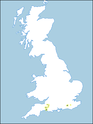
Distribution Map
 |
Note that the yellow shading represents a buffer to highlight the location of very small areas of the association.
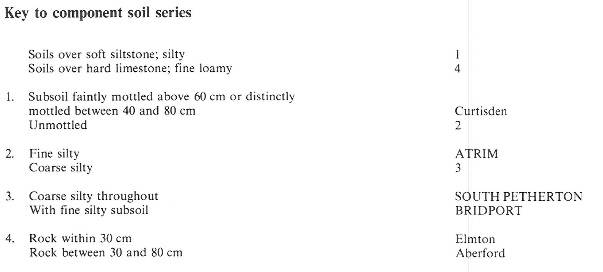
Keys to component soil series
South Western Region
 |
All information Copyright, Cranfield University © 2025
Citation: To use information from this web resource in your work, please cite this as follows:
Cranfield University 2025. The Soils Guide. Available: www.landis.org.uk. Cranfield University, UK. Last accessed 25/04/2025
