
Soil Associations
0541s WICK 2
Soil and site characteristics
Deep well drained coarse loamy soils often stoneless. Some similar soils with slowly permeable subsoils and slight seasonal waterlogging. Slight risk of water erosion.
Geology
Glaciofluvial and aeolian drift and till
Cropping and Land Use
Cereals, peas and beans, sugar beet and potatoes; horticultural crops and field vegetables.
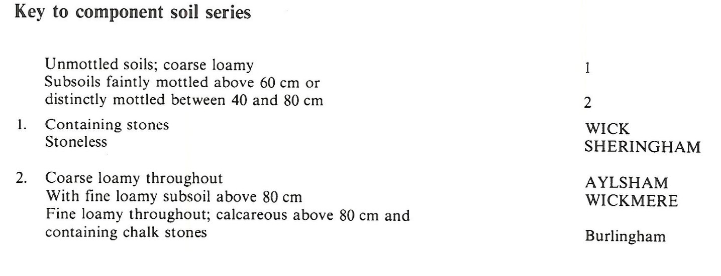
Component soil series
| Subgroup | Series name | Percentage | WRB 2006 link |
|---|---|---|---|
| 5.41 | WICK | 36% | Eutric Cambisols |
| 5.72 | WICKMERE | 34% | Ruptic Endostagnic Luvisols |
| 5.41 | SHERINGHAM | 15% | Eutric Cambisols |
| 5.43 | AYLSHAM | 10% | Eutric Endogleyic Cambisols |
Covers 483 km2 in England and Wales
Soilscapes Classification
| 6 |
Freely draining slightly acid loamy soils |
0541s WICK 2
Detailed Description
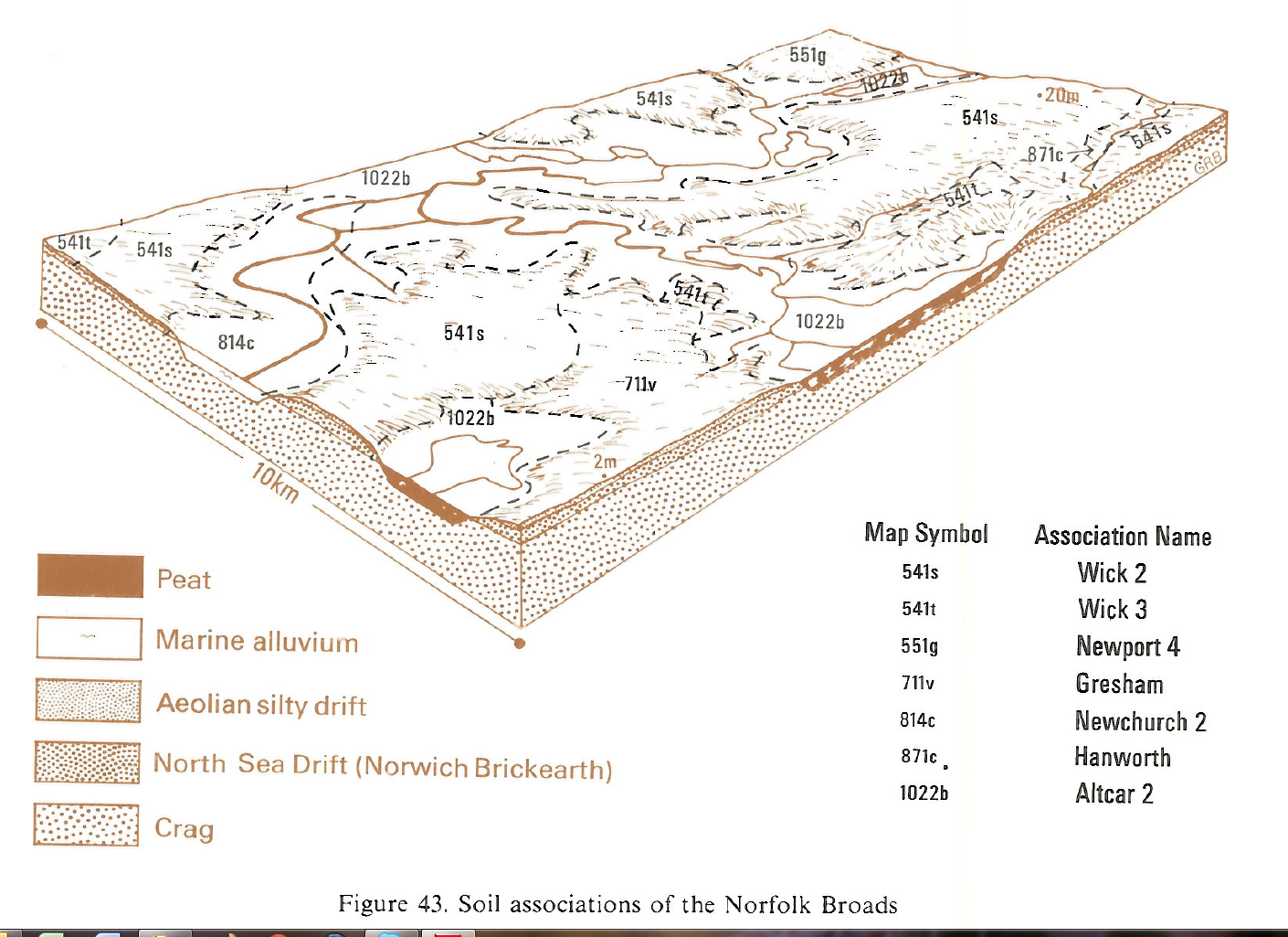
This association of deep coarse loamy soils covers 454 km² in Norfolk forming much of the land between Sheringham, Norwich and Great Yarmouth, with smaller areas to the west in the upper Glaven valley and near Melton Constable and Heydon. The land is gently undulating, ranging from a little above sea level in the Broads and on the coast, to about 90 m O.D. on the Cromer Ridge behind Sheringham. The soils are formed mostly in thin aeolian drift, but their lower layers are often in the underlying till (Norwich Brickearth) or glaciofluvial sands. The main soils belong to the very slightly stony Wick series, typical brown earths, which includes soils previously mapped as Hall series by Corbett and Tatler (1974), with lower subsoils that are usually sandy, and the stoneless Wickmere series, stagnogleyic argillic brown earths, with a brown, loamy lower subsoil. These soils make up more than two-thirds of the association. Where the aeolian drift is thickest Sheringham series, typical brown earths, occurs and is associated with small areas of the similar, but mottled Aylsham series, gleyic brown earths.
Generally, Wick soils are found on high ground with Wickmere soils on the slopes. Small dry valleys contain Sheringham soils and in the lower, wetter parts, Aylsham series. The sandy silt loam upper layers of Wickmere soils in the west pass directly down into sandy clay loam, but around Horning there is usually a thin sandy loam layer between these upper and lower layers. Burlingham series replaces Wickmere series, where the till is chalky south-west of Acle.
Soil Water Regime
Wick and Sheringham soils have permeable surface and subsurface layers unaffected by groundwater and are well-drained (Wetness Class I). Wickmere soils have mottled moderately permeable subsoils but with drainage measures are largely well-drained. The permeable subsoils of the Aylsham series are naturally waterlogged in winter (Wetness Class II and III), but where the water-table has been lowered these soils are now well-drained. All the soils are water-retentive and non-droughty for the deeper-rooting crops such as sugar beet and slightly droughty for other crops, except grass, in normal years. Crops grown on the Wick series with sandy lower subsoils are the most likely to be affected by drought in dry years .
Cropping and Land Use
The soils are easily worked and there is ample time in both autumn and spring in normal years during which cultivations can be made without damage to soil structure. There is some restriction on Wickmere and Burlingham soils in very wet springs. Having large silt and small organic matter contents, the topsoils of all component soils slake and cap after heavy rain and seedling emergence can be adversely affected. The association provides some of the most valuable land in Norfolk as the soils are flexible to manage and consistently give high yields. Cereals are mainly autumn sown and large areas of sugar beet and maincrop potatoes are grown as well as field vegetables. Horticultural crops and soft fruit are grown locally.
0541s WICK 2
Distribution Map
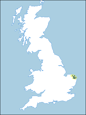 |
Note that the yellow shading represents a buffer to highlight the location of very small areas of the association.
Keys to component soil series
Eastern Region
 |
Typical Landscapes
Eastern Region
 |
All information Copyright, Cranfield University © 2025
Citation: To use information from this web resource in your work, please cite this as follows:
Cranfield University 2025. The Soils Guide. Available: www.landis.org.uk. Cranfield University, UK. Last accessed 25/04/2025
