Soil Associations
0541t WICK 3
Soil and site characteristics
Deep well drained coarse loamy often stoneless soils. Some similar sandy soils. Complex pattern locally. Risk of water erosion
Geology
Glaciofluvial and aeolian drift
Cropping and Land Use
Cereals, peas and beans, sugar beet and potatoes, some field vegetables and horticultural crops, including bulbs.
Component soil series
| Subgroup | Series name | Percentage | WRB 2006 link |
|---|---|---|---|
| 5.41 | WICK | 55% | Eutric Cambisols |
| 5.41 | SHERINGHAM | 25% | Eutric Cambisols |
| 5.51 | NEWPORT | 10% | Eutric Arenosols |
Covers 323 km2 in England and Wales
Soilscapes Classification
| 6 |
Freely draining slightly acid loamy soils |
0541t WICK 3
Detailed Description
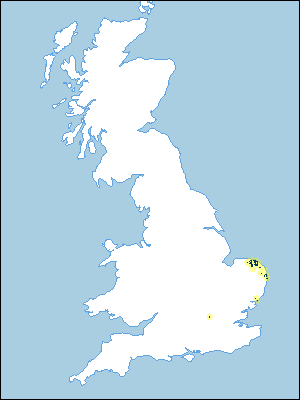
This association covers 305 km² mainly in north-east Norfolk but also in south-east Norfolk and Suffolk between Lowestoft and Great Yarmouth and near Felixstowe. There are small outlying occurrences in west Norfolk and near Rickmansworth, Hertfordshire. The largest area, on relatively flat ground up to 90 m O.D. on the crest of the Cromer ridge, is dissected on its southern flank by relatively steep sided valleys. Elsewhere the association provides generally flat ground, as along the Bure and Ant and on the coastal plateau near Great Yarmouth and in Suffolk. In Hertfordshire it occurs on a gently sloping river terrace. These surfaces are thinly covered by aeolian drift which rests on glaciofluvial deposits, river terrace sands and gravels, or Crag. Thus the main soils have a large silt content. The main Wick series (typical brown earths) includes soils originally mapped as Hall series and covers more than half the land. It is slightly or very slightly flinty and the lower subsoil is commonly sandy. Where the contribution of aeolian drift is greatest the similar, but generally more silty and stoneless Sheringham series is found extending over a further quarter of the land. Where there is little aeolian material as on slopes, the Newport series, typical brown sands, previously mapped as Freckenham series, is a characteristic minor component.
Generally the Wick series occurs on level or gently sloping land with the Sheringham series in dry valleys but often the soil pattern is complex with Sheringham soils extending from valley bottoms onto lower slopes especially those facing north and east. The streaked patterns revealed by better crop growth on the deeper soils suggests that the aeolian material was redistributed by solifluction following deposition. There are some sandy podzolized Redlodge soils associated with Newport soils on the Cromer Ridge. Ebstree soils occur on steeper sloping land in Suffolk. Reddish coarse loamy Maxted soils and Berkhamsted and Hornbeam serieswith clayey subsoils occur locally near Felixstowe. Hall series, similar to Wick soils but with gravelly subsoils is common near Rickmansworth.
Soil Water Regime
Wick, Sheringham and Newport series have permeable surface and subsurface layers and are unaffected by groundwater so they are naturally well-drained (Wetness Class I). Though rainfall is normally readily absorbed, heavy rainfall can cause gully erosion on bare sloping ground where the surface soil has been compacted. Sheringham and Wick soils are slightly droughty for cereals as, marginally, are the more water-retentive Sheringham soils. All three soils are non-droughty for sugar beet, moderately droughty for potatoes, which require irrigation for optimum yields, and very droughty for grass. Newport soils are moderately and very droughty for arable crops and grass respectively.
Cropping and Land Use
The soils are easily worked and there is adequate time for cultivations in both autumn and spring. Direct drilling is not advisable because of the low organic matter content and coarse loamy or sandy textures of the soils. There is likely to be a loss of yield especially in spring sown crops. The main crops are barley, both autumn and spring sown, and sugar beet. Much less wheat is grown than barley and field vegetables, mainly peas and main crop potatoes, are common. Sheringham and Wick series are valuable and flexible soils, but overall yields are reduced where Newport soils form droughtier spots within fields.
0541t WICK 3
Distribution Map
 |
Note that the yellow shading represents a buffer to highlight the location of very small areas of the association.
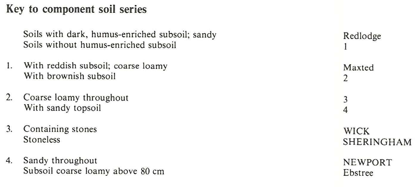
Keys to component soil series
Eastern Region
 |
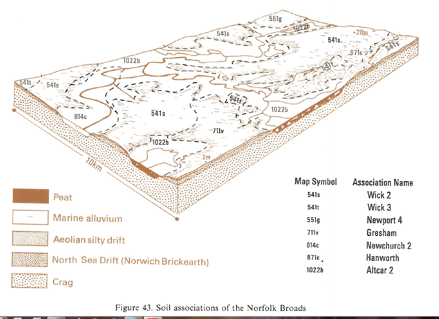
Typical Landscapes
Eastern Region
 |
All information Copyright, Cranfield University © 2025
Citation: To use information from this web resource in your work, please cite this as follows:
Cranfield University 2025. The Soils Guide. Available: www.landis.org.uk. Cranfield University, UK. Last accessed 25/04/2025
