
Soil Associations
0541y EAST KESWICK 2
Soil and site characteristics
Deep well drained fine and coarse loamy soils. Steep slopes locally.
Geology
Drift from Palaeozoic and Mesozoic sandstone and shale
Cropping and Land Use
Coniferous woodland on steep slopes; some grassland on gentle slopes.
Component soil series
| Subgroup | Series name | Percentage | WRB 2006 link |
|---|---|---|---|
| 5.41 | EAST KESWICK | 65% | Dystric Cambisols |
| 5.41 | NEATH | 20% | Eutric Endoleptic Cambisols |
| 5.41 | WICK | 15% | Eutric Cambisols |
Covers 179 km2 in England and Wales
Soilscapes Classification
| 6 |
Freely draining slightly acid loamy soils |
0541y EAST KESWICK 2
Detailed Description
The association consists predominantly of coarse and fine loamy typical brown earths, in drift derived from Carboniferous and Jurassic shales interbedded with sandstones, on steep valley sides or escarpments. It occurs in Durham, Yorkshire, Cheshire and Derbyshire at heights ranging from 20 to 300 m O.D. Slopes vary greatly but are generally steeper than 4 degrees, with much land up to 25 degrees or more. The fine loamy East Keswick series, formerly Ambergate series, and the coarse loamy Wick series occur on slopes where the drift is more than 80 cm thick. The Neath series, fine loamy over sandstone, is found on convex upper or middle slopes.
Approximately 108 km² of the association have been mapped in Northern England. In West Yorkshire it is associated with steep valley sides and escarpments of the Lower Coal Measures around Huddersfield, Halifax, Leeds and Bradford. Where the drift thins over gritstone and coarse sandstones there are coarse loamy Rivington and Belmont soils. The land is under coniferous or mature deciduous woodland on the steep sides of valleys draining the northern parts of the North York Moors, above Staithes and Sandsend. Soils on steep slopes surrounding Farndale are also included. In the Pennines the association is found on valley sides, as in Weardale between Wolsingham and Burnhope. Smaller areas have been mapped around Middleton-in-Teesdale, Richmond and between Harrogate and Skipton.
Soil Water Regime
East Keswick, Neath and Wick soils are well drained (Wetness Class I). Occasional seasonally waterlogged sites are associated with Bardsey and Heapey soils (Wetness Class III). The soils are absorbent and, despite the steep slopes, there is little winter run-off
Cropping and Land Use
Because cultivation and cropping are restricted by gradient, the soils are mostly under poor grassland, scrub or managed deciduous and coniferous woodland, but occasional arable fields are found. On ground sloping less than 11 degrees grassland can be managed intensively and fields with favourable aspect are cultivated. There is little risk of poaching or rutting. Trees in hardwood plantations are closely spaced on lower ground, but on the exposed edges they are planted further apart and belong to hardier species. Sycamore, oak and beech are the commonest hardwoods, with Scots pine, European larch and Norway spruce the usual softwoods. All wooded areas have much amenity value by virtue of the steep terrain.
0541y EAST KESWICK 2
Distribution Map
 |
Note that the yellow shading represents a buffer to highlight the location of very small areas of the association.
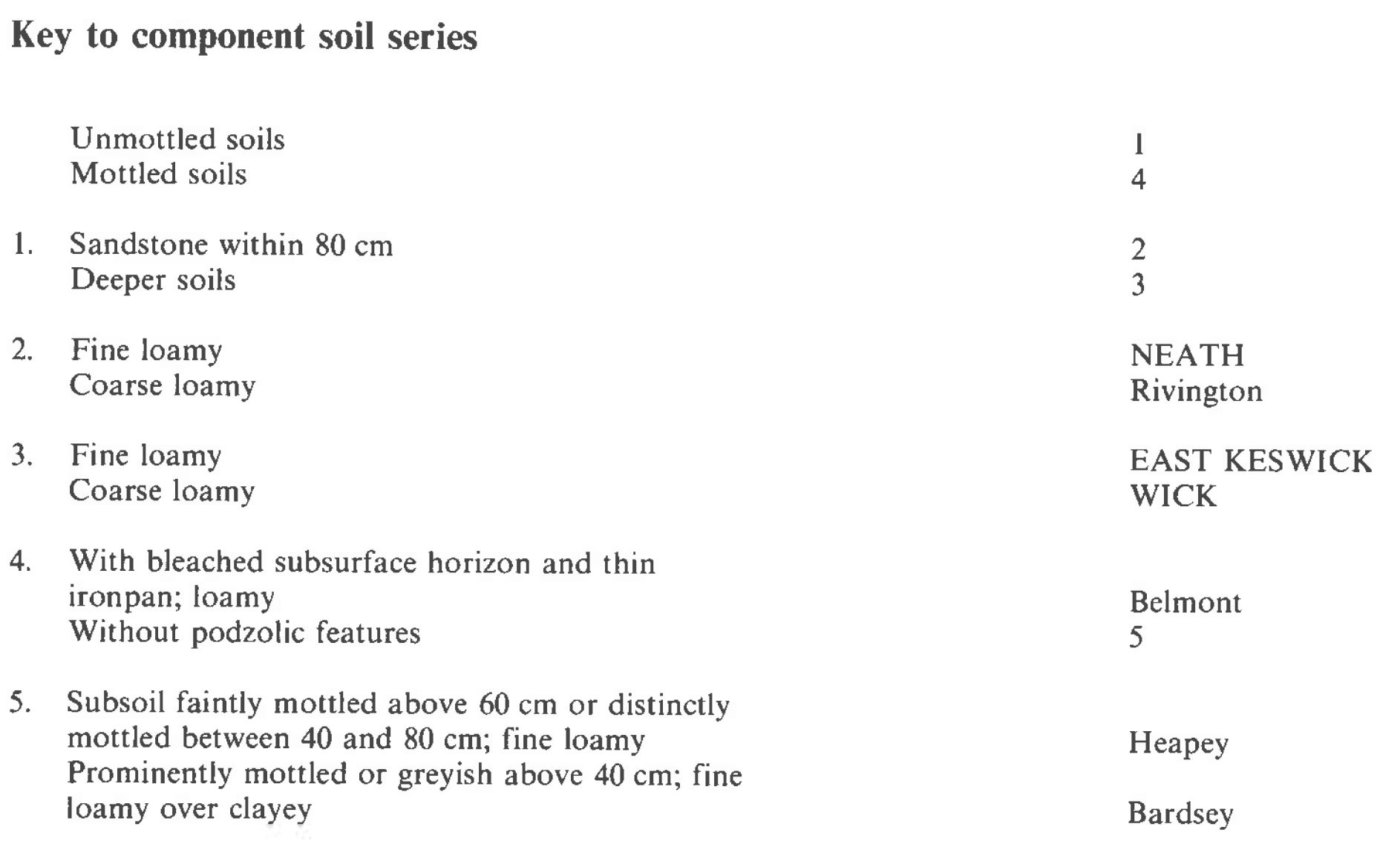
Keys to component soil series
Midlands
 |
Northern Region
 |
Typical Landscapes
Midlands
 |
All information Copyright, Cranfield University © 2025
Citation: To use information from this web resource in your work, please cite this as follows:
Cranfield University 2025. The Soils Guide. Available: www.landis.org.uk. Cranfield University, UK. Last accessed 25/04/2025
