
Soil Associations
0581e MARLOW
Soil and site characteristics
Well drained fine loamy over clayey and clayey soils. Some coarse and fine loamy over clayey soils with slowly permeable subsoils and slight seasonal waterlogging.
Geology
Plateau and river terrace drift
Cropping and Land Use
Cereals and short term grassland; coniferous woodland on slopes.
Component soil series
| Subgroup | Series name | Percentage | WRB 2006 link |
|---|---|---|---|
| 5.81 | MARLOW | 45% | Profundic Chromic Luvisols |
| 5.82 | BERKHAMSTED | 10% | Abruptic Chromic Endostagnic Luvisols |
| 5.82 | HORNBEAM | 10% | Chromic Endostagnic Luvisols |
| 5.81 | WINCHESTER | 10% | Clayic Chromic Endoleptic Luvisols |
Covers 218 km2 in England and Wales
Soilscapes Classification
| 6 |
Freely draining slightly acid loamy soils |
0581e MARLOW
Detailed Description
The association consists mainly of flinty loamy over reddish and red-mottled clayey soils, developed in Plateau Drift and river terrace drift over chalk or sandy limestone. The upper horizons of most soils contain aeolian silty drift. The association is found on level or gently sloping land above 120 m O.D. on the Chiltern Hills, the North Downs and the South Downs but it is also mapped in Kent on the highest parts of the Lower Greensand between Sevenoaks and Harrietsham. Marlow soils, typical paleo-argillic brown earths, with flinty fine loamy upper layers over well structured yellowish red clay are dominant everywhere. The most important associate soils are similar stagnogleyic paleo-argillic brown earths, mainly Berkhamsted series which has flinty coarse loamy upper horizons, and Hornbeam series with fine loamy upper horizons. Both have reddish or red-mottled clayey subsoils that are moderately permeable and have greyish mottles and ped faces. Where the drift thins over chalk there are clayey Winchester soils, typical paleo-argillic brown earths; these are mainly restricted to plateaux edges. In most districts the main soils take up nearly three-quarters of the land. The other component soils vary because the Plateau Drift has been derived from varied sandy, loamy and clayey Tertiary strata, chiefly Reading Beds. Over Lower Greensand the drift is derived mainly from Sandgate Beds.On the Chilterns the association occurs along the lower dipslope between Chorleywood and St Albans. The soils are formed in a thin loamy superficial drift over clayey Plateau Drift which in turn overlies gravel deposits along an early course of the Thames. Marlow soils, with well drained Winchester and Givendale soils on upper valley slopes, occupy nearly half of the area. Berkhamsted and Hornbeam soils occur on the gently sloping or slightly undulating plateau. Deep loamy well drained Maplesteadand Ludford soils occur both on the plateau and on the valley sides. Frilsham, Moulton, Upton and Soham soils occur on steeper land where the valleys cut through to the Chalk. Marlow and Givendale soils are dominant near Salisbury Hall, London Colney. Here lower slopes are masked by silty aeolian drift giving Batcombe and Charity soils.
On the Chilterns there are several large irregular patches of the association on ridge crests near High Wycombe and Amersham. Here the land is slightly undulating but some steeper ground at the heads of the valleys which has Frilsham soils is included. Carstens soils occur where aeolian silty drift is thicker and particularly north-west of Marlow. Sandy gravelly St Albans and Southampton soils are developed in coarse-textured drifts on some ridges. Winchester and Givendale soils occur mainly on the shoulders of the ridges.
The association also occurs on a gently sloping bench near the foot of the Chalk escarpment east of Wallingford, where the Wallingford gravels rest on hard chalk. The gravels are similar to Plateau Drift but include thick coarse-textured material in which Sonning and Bockmer soils are developed. These patches are often fringed by well drained deep, fine loamy Sheldwich soils. Ludford soils are common downslope in the west. The soil pattern is usually complex everywhere.
On the highest parts of the North Downs, between Guildford and Dorking and east of the Mole Gap, the soils are developed in the sandy and gravelly Netley Heath Deposits. Here Winchester and Givendale soils are rare because the drift is generally thick. Well drained coarse loamy Maxted soils with reddish clay at depth, are common in coarse-textured patches near Ranmore Common and on Headley and Netley Heaths. Carstens and Batcombe soils with flinty fine silty upper layers, occur in many places as small patches where there is some aeolian silty drift. Loamy Moulton, Maplestead, Weasenham and Ludford soils are occasionally included in the heads of valleys. The small area west of Farnham includes some Oak soils. Here the parent material is Head, much disturbed by cryoturbation, which contains material from Reading Beds as well as sand, loam and gravel from former river terraces. On the South Downs between Brighton and Eastbourne, soils with fine loamy upper horizons predominate, and Berkhamsted soils are rare. The deposits thin rapidly towards ridge shoulders where clayey Winchester and Givendale soils are common.
On the Hythe Beds in Kent the association is found on Angular Chert Drift which is characterised by angular cherty sandstone fragments from the Lower Greensand. Here flints are rare and the soils were mapped as the Willington association. Willington series has now been correlated with Marlow series. Hornbeam soils are common in this district and Berkhamsted soils locally frequent. Batcombe soils occur where the parent material includes much aeolian silty drift. Maplestead and Ludford soils are developed in deep loamy drift in dry valley heads.
Soil Water Regime
Marlow and Winchester soils are well drained (Wetness Class I) despite having clayey subsoils. The latter are well structured allowing free percolation of drainage water to the porous rock beneath. The land readily accepts excess winter rain. The clayey subsoils of Berkhamsted and Hornbeam soils are less well structured and moderately permeable but the presence of a chalk substratum ensures that these soils are only occasionally waterlogged (Wetness Class II or III) and land drainage is rarely necessary for common agricultural crops. The principal soils have good reserves of water available for crop growth and they are slightly droughty for cereals but moderately droughty for potatoes and very droughty for grass.
Cropping and Land Use
There are long periods in autumn when the soils can be cultivated but there are fewer opportunities in spring, and in wet seasons the number of suitable days is very restricted. The stony ground causes implement wear, limits precision drilling and makes the harvesting of root crops difficult. The land is largely arable, mainly winter cereals with grass leys. Poaching risk is negligible in average years but grass production is seriously limited by drought. The soils have a natural tendency towards acidity so regular liming is needed. Topsoils cap and pan where amounts of organic matter are small.
There are semi-natural mixed deciduous woodlands at Netley Heath, Ranmore Common and Box Hill on the North Downs. The natural acidity of the soils is reflected in the character of the woodland which contrasts sharply with the calcicolous vegetation of adjacent chalk scarps. The main trees are oak or beech with oak, often accompanied by birch, ash and gean. Holly and yew are common in the shrub layer and the ground flora consists of honeysuckle (Lonicera periclymenum), bramble (Rubus spp.) and wood sage (Teucrium scorodonia) with bracken (Pteridium aquilinum) in the open areas such as Ranmore Common.
0581e MARLOW
Distribution Map
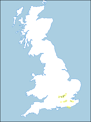 |
Note that the yellow shading represents a buffer to highlight the location of very small areas of the association.
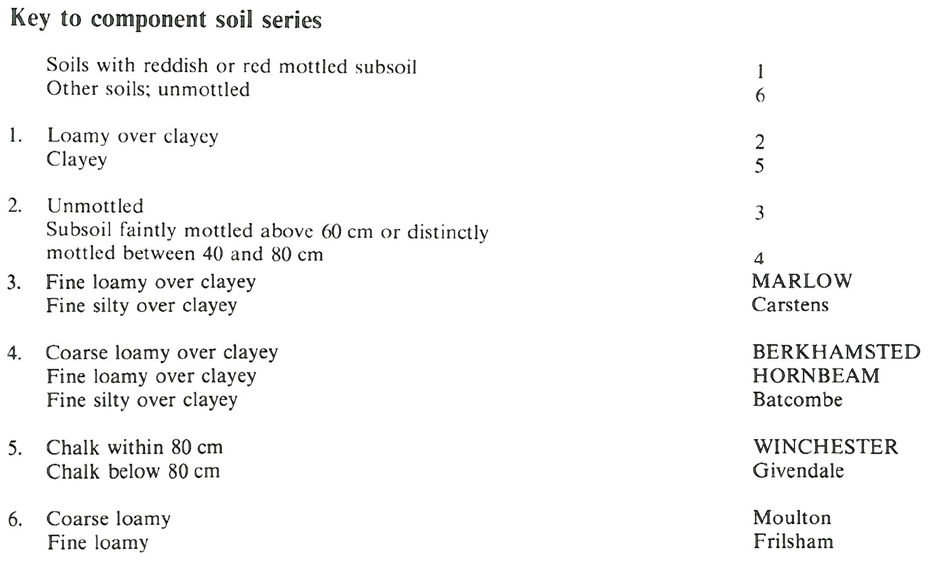
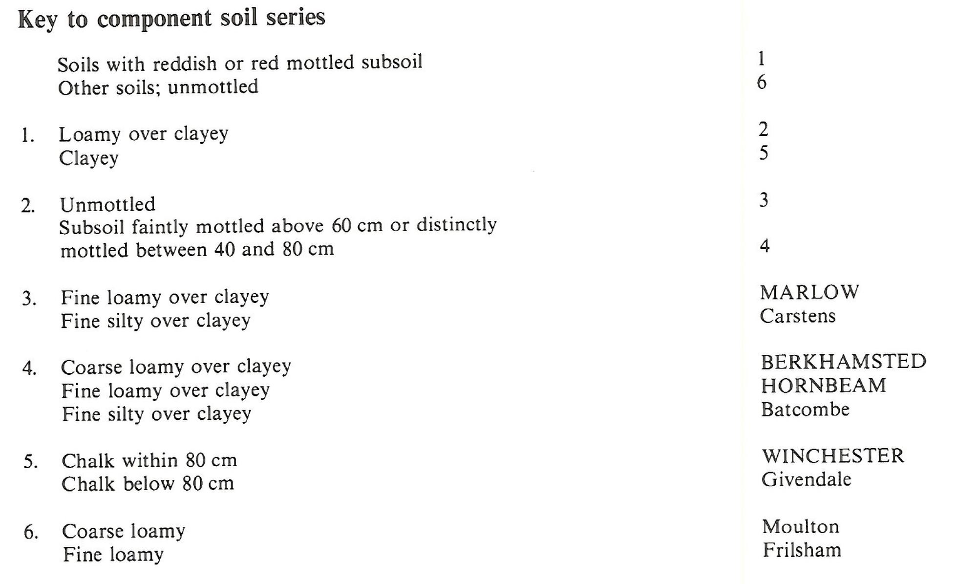
Keys to component soil series
South Eastern Region
 |
Eastern Region
 |
All information Copyright, Cranfield University © 2025
Citation: To use information from this web resource in your work, please cite this as follows:
Cranfield University 2025. The Soils Guide. Available: www.landis.org.uk. Cranfield University, UK. Last accessed 25/04/2025
