
Soil Associations
0581f BARROW
Soil and site characteristics
Deep well drained coarse loamy, coarse loamy over clayey and sandy soils. Some of the latter very acid and with a bleached subsurface horizon especially in woodlands or on heaths.
Geology
Chalky till and glaciofluvial drift
Cropping and Land Use
Cereals, sugar beet, potatoes and winter vegetables; some short term grassland, lowland heath habitats and coniferous woodland.
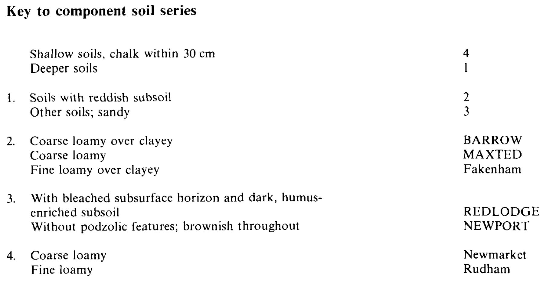
Component soil series
| Subgroup | Series name | Percentage | WRB 2006 link |
|---|---|---|---|
| 5.81 | BARROW | 55% | Profundic Chromic Luvisols |
| 5.81 | MAXTED | 20% | Ruptic Chromic Luvisols |
| 5.51 | NEWPORT | 15% | Eutric Lamellic Arenosols |
| 6.31 | REDLODGE | 10% | Albic Podzols |
Covers 287 km2 in England and Wales
Soilscapes Classification
| 6 |
Freely draining slightly acid loamy soils |
0581f BARROW
Detailed Description
The Barrow association consists of deep, well drained, non-calcareous, mainly coarse loamy over clayey soils, with some coarse loamy and sandy soils. It covers 290 km² in north-west Norfolk reaching 90 m O.D. It occurs on flat or gently sloping ground. The soils are formed mainly in chalky till where substantial additions of aeolian sand have been incorporated into the upper layers, and partly in glaciofluvial sands and gravels in the dry valleys leading to the head waters of the Wensum. The main soils are the Barrow and Maxted series, both typical paleo-argillic brown earths, which cover three-quarters of the land, the former being the more widespread. The very slightly flinty upper horizons of Barrow soils pass to a thick reddish brown clay subsoil which overlies pale-coloured calcareous till. Maxted soils have similar, thicker, upper layers passing downwards to reddish-brown sandy clay loam then clay which again rests on calcareous till but at 1.2 to 2.5 m depth. Newport series, typical brown sand, and Redlodge series, humo-ferric podzols, occur on the glaciotluvial sands, the latter having an upper subsoil layer of dark, humus-cemented sand. Fakenham, Newmarket and Rudham soils also occur.
Deep Maxted soils are most common on the flat highest ground, Barrow series becoming more frequent on lower land towards the perimeter of the mapped areas where the chalky till and Head are closer to the surface. Rubbly chalky Head is most common on steep convex slopes where shallow, Newmarket and Rudham series, coarse and fine loamy respectively, alternate with deeper fine loamy over clayey Fakenham soils. Redlodge soils tend to occur on the more stony and low-lying of the glaciofluvial drifts.
Soil Water Regime
All the soils in this association are permeable and well drained (Wetness Class I). Winter rainfall is easily absorbed. Table 18 shows estimates of water available to the main crops on the principal soils, the average moisture deficits and the consequent likely droughtiness. The extensive Barrow and Maxted soils are slightly droughty for cereals, oilseed rape and potatoes, non-droughty for the deeper-rooting sugar beet and moderately droughty for grass. The sandy Newport and Redlodge series are more droughty than the loamy soils because of their low waterholding capacity which is mainly in the coarse loamy topsoils but, because of the higher rainfall in this part of Norfolk, are appreciably less droughty than the same soils elsewhere in Norfolk and Suffolk. There is some risk of wind erosion.
Cropping and Land Use
There is normally ample time for harvesting sugar beet as well as for autumn and spring cultivations on these easily worked soils, though there are some restrictions, especially on the loamy soils, in wet years. Landwork is possible during the field capacity period within a week of heavy rain, or sooner on the sandy soils. Reduced or minimum cultivations in autumn are of doubtful advantage on these soils. The main crops are barley, mostly autumn sown, sugar beet and winter wheat. There is a tradition of winter-harvested vegetables, chiefly carrots, but including parsnips and brussels sprouts and there is some ley grassland for stock rearing. The landscape is open with large fields, shelter belts and some woodland and lowland heaths, the latter largely on Newport and Redlodge soils. Young (1804) included this land within the district he called "Good Sand" which he says contained "large tracts of excellent land, intermixed with a good deal of an inferior quality. Here is found the agriculture to which the general epithet of Norfolk husbandry peculiarly belongs".
0581f BARROW
Distribution Map
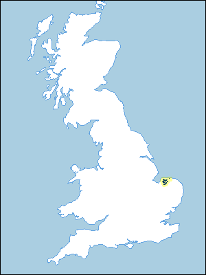 |
Note that the yellow shading represents a buffer to highlight the location of very small areas of the association.
Keys to component soil series
Eastern Region
 |
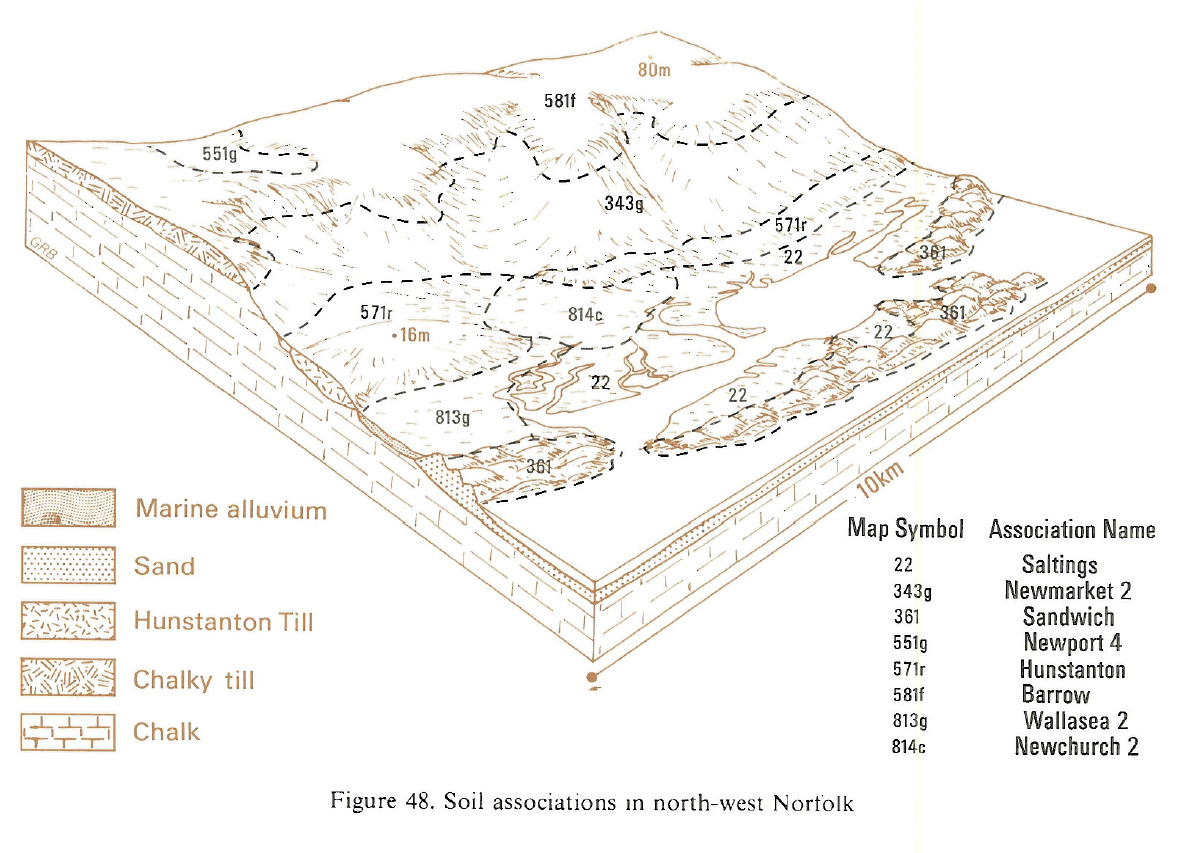
Typical Landscapes
Eastern Region
 |
All information Copyright, Cranfield University © 2025
Citation: To use information from this web resource in your work, please cite this as follows:
Cranfield University 2025. The Soils Guide. Available: www.landis.org.uk. Cranfield University, UK. Last accessed 25/04/2025
