Soil Associations
0832 KELMSCOT
Soil and site characteristics
Calcareous fine loamy soils over gravel variably affected by groundwater, associated with non-calcareous clayey soils over gravel. Flat land. Risk of flooding.
Geology
River terrace drift
Cropping and Land Use
Winter cereals and some permanent grassland.
Component soil series
| Subgroup | Series name | Percentage | WRB 2006 link |
|---|---|---|---|
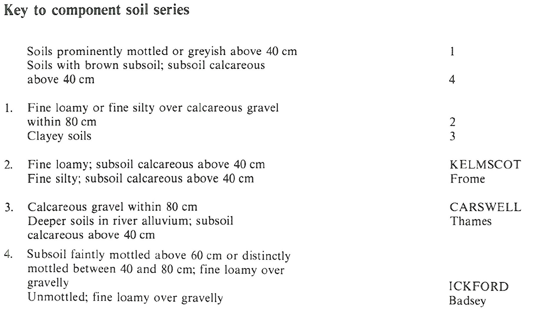
| 8.32 | KELMSCOT | 60% | Endoskeletic Calcaric Mollic Gleysols |
| 8.33 | CARSWELL | 10% | Epiclayic Endoskeletic Calcaric Gleysols |
| 5.12 | ICKFORD | 10% | Calcaric Endogleyic Endoskeletic Cambisols |
Covers 90 km2 in England and Wales
Soilscapes Classification
| 22 |
Loamy soils with naturally high groundwater |
0832 KELMSCOT
Detailed Description
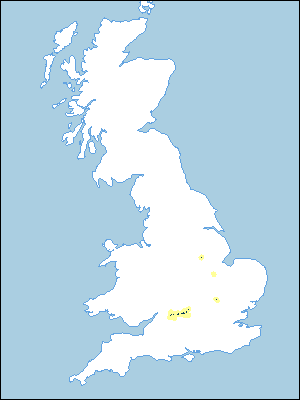
The Kelmscot association consists mainly of calcareous fine loamy soils over limestone gravel. It is found on low-lying river terrace drift affected at shallow depth by groundwater chiefly in the Thames valley but also in small areas in Nottinghamshire, Lincolnshire and Bedfordshire. The principal soil, the Kelmscot series, is a calcaro-cambic gley soil with a grey fine loamy subsoil over limestone gravel. Associated soils include the Carswell series), pelo-cambic gley soils in clay over gravel, and fine loamy over gravelly gleyic brown calcareous earths of the Ickford series which occur on slightly higher ground with some Badsey soils. Gade series with a thick humose topsoil is confined to old river channels or other shallow depressions, and clayey and loamy alluvial soils of the Thames and Frome series occur near the rivers. The association occurs in Bennington Fen south of Newark, where the soil pattern reflects that of former watercourses infilled during land reclamation. Kelmscot soils which cover half the land are associated with calcareous clayey soils of the Thames, Earith and Carswell series. The non-calcareous Stixwould series and the calcareous loamy Gubblecote series are also present. The association is also found in the Ivel valley in Bedfordshire where Kelmscot series is the dominant soil. Most component soils are permeable and overlie gravel but are affected by groundwater and flooding.
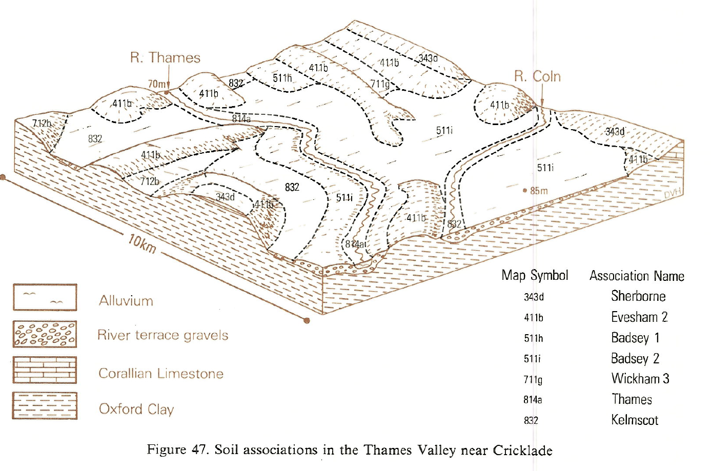
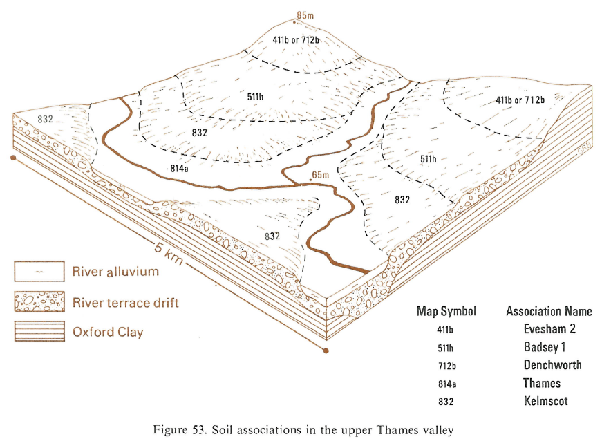
These soils cover some 30 km² on both sides of the Thames above Lechlade. In the lower reaches of the Leach, Coln and the Churn they cover the entire valley floor, but along the Thames they are on terraces slightly above floodplain soils of the Thames association. Ickford soils are confined to slightly higher ground, whereas the wetter Gade series is found in old river meander channels and other depressions mainly in north bank tributaries. There are also some gravel workings and restored land.
These soils occur on the low-lying Thames floodplain between Oxford and Lechlade, some parts of which have been mapped in detail. The soils are developed in low terrace deposits which rise slightly above the floodplain alluvium thus separating the Thames association from the higher terrace soils of the Badsey association. In the lower reaches of north bank tributaries, the association occupies whole valley floors and includes Gade soils in in-filled channels and ditches. Ickford and Badsey soils are confined to higher ground, some distance from the main river. Carswell soils are locally dominant south of the Thames. Shabbington soils and non-calcareous loamy over gravelly soils are common near Yarnton. Some gravel workings and restored land are also present.
Soil Water Regime
Most of the soils are permeable but are affected by shallow groundwater and flooding. Depending on outfalls and field drainage measures, waterlogging may be short-term and confined to winter, or prolonged into the growing season (Wetness Class II to IV). Given good outfalls and protection from flooding the gravel substratum allows the soils to drain easily. In the less permeable, clayey Thames and Carswell soils, good arterial and in-field drainage are necessary to effect much improvement in the soil water regime.
Cropping and Land Use
Most of the land is effectively drained and free from flooding and is arable with winter cereals, sugar beet and potatoes. Patches of Thames and Gade soils, where present, delay cultivations. Because the soils are calcareous, sensitive crops are at risk from manganese deficiency. Depth to gravel varies and, in particularly dry years, differential crop growth indicates that there is patterned ground locally. Wetter land with poor outfalls or risk of flooding is commonly in grassland. In most years there are ample opportunities for cultivation in autumn but there are fewer suitable days in spring. Carswell soils offer a limited period for autumn tillage in wet seasons, however, and opportunities in spring are also very limited. Land with poor outfalls and risk of flooding is mainly in grassland with good yield potential but appreciable poaching risk which restricts early and late grazing. Much of the land with improved drainage and flood protection along the Thames is in arable cropping, but patches of Thames and Gade soils may remain wet longer and delay cultivations. Because the soils are calcareous and topsoils may contain a large amount of organic matter, sensitive crops sometimes suffer from manganese deficiency. Depth of soil over gravel is rather variable and differential crop growth in dry years occasionally reveals patterned ground.
0832 KELMSCOT
Distribution Map
 |
Note that the yellow shading represents a buffer to highlight the location of very small areas of the association.
Keys to component soil series
South Eastern Region
 |
Typical Landscapes
South Western Region
 |
South Eastern Region
 |
All information Copyright, Cranfield University © 2025
Citation: To use information from this web resource in your work, please cite this as follows:
Cranfield University 2025. The Soils Guide. Available: www.landis.org.uk. Cranfield University, UK. Last accessed 25/04/2025
